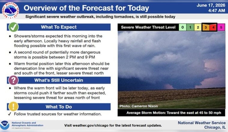
Chicago woke up to cool, muggy air on Wednesday, June 17, 2026, with temperatures hovering near 59°F downtown. Do not let the sleepy start fool you, though, a band of heavy showers and thunderstorms is lined up to move through today, bringing strong wind gusts and the potential for quick, urban flash flooding. The high should top out near 69°F, but the most intense storms could dump 2 to 3 inches of rain in a short burst and make driving tricky. Keep an eye on alerts and have a backup plan ready for any outdoor plans this afternoon and evening.
Afternoon Threats And Timing
Rain is likely to develop by mid-morning, with the heaviest action expected from about 11 a.m. to 4 p.m. on Wednesday, June 17, 2026. Thunderstorms in this window may produce damaging wind gusts and very heavy downpours that quickly cut visibility. A Flood Watch is in effect from 10:00 a.m. CDT through this evening, and forecasters say localized totals of 2 to 3 inches are possible in the hardest-hit areas, which raises the risk of flash flooding, according to NWS Chicago.
Commute And Safety
Gusty south-southwest winds will make walking and bike commutes a slog and could knock over unsecured objects, while buses and surface streets may slow to a crawl during the heaviest rain bursts. If you have outdoor plans, move them inside or postpone, secure patio furniture and grills now, and avoid driving through standing water, no matter how shallow it looks. Similar concerns popped up in a wind-whipped forecast earlier this week, and the new Flood Watch only boosts the odds of travel-disrupting flash flooding today.
Lake And Marine Hazards
The lakefront is in for a rough stretch this afternoon into tonight. A Beach Hazards Statement calls for 4 to 7 foot waves and dangerous currents, and small craft advisories are posted for the nearshore waters. Officials are urging people to remain out of the water and to steer clear of piers, jetties, and breakwalls while the high waves are rolling. Boat operators should delay outings, and swimmers should follow lifeguard instructions and the city's beach flag system. These marine hazards are detailed by NWS Chicago.
Looking Ahead
Conditions calm down on Thursday, with mostly sunny skies and highs in the mid-70s, but the pattern stays active, and another system could bring showers and storms by Sunday. Keep weather alerts turned on if you are planning large outdoor gatherings, and check local advisories before heading to the lakefront or launching small boats. Stay tuned to official channels for any additional watches and warnings through this evening and into the overnight hours.


