Minneapolis is waking up to clouds, muggy air and a potential mess on the roads, with a line of showers and thunderstorms expected to sweep across the metro before midday Sunday. After the storms move through and a breezy, unsettled day wraps up, the weather flips hard into summer furnace mode, with a dangerous heat event expected to peak Monday.
A corridor of storms is forecast to move through between about 7 a.m. and 10 a.m. Sunday, sliding east across the Minneapolis–St. Paul area. These storms could pack large hail and damaging wind gusts. Southeast winds are expected to climb into the mid-teens, with gusts near 25-30 mph at times, raising the odds of slick pavement and brief visibility issues during the morning drive. According to the National Weather Service Twin Cities, this morning’s line has the potential to be strong as it tracks east.
Today And Sunday Night
Skies stay mostly cloudy through the day with a high near 82°F and scattered showers or a rumble of thunder at times. Most neighborhoods will only see a few tenths of an inch of rain, but a pocket or two of heavier downpours cannot be ruled out. A steady southeast breeze will be noticeable all afternoon, and rising humidity will make it feel stickier than the number on the thermometer suggests. There is still a chance of additional showers and storms into Sunday night, so outdoor plans may face on-and-off interruptions.
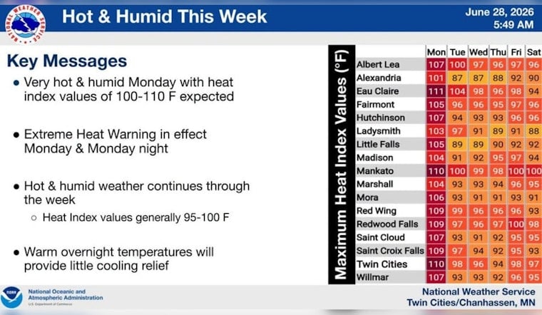
Extreme Heat Monday
Monday is when the real weather whiplash hits. Forecasts show highs surging into the mid-to-upper 90s, with heat index values pushing close to 110°F, creating dangerous conditions for anyone without reliable air conditioning. The National Weather Service has placed the area under an Extreme Heat Warning from 9 a.m. Monday through midnight Monday night, and officials caution that heat-related illnesses will become more likely during that window. People who work or exercise outside are urged to shift strenuous activity to early morning or evening hours and take frequent water breaks.
Cooling Options And Safety
If you do not have air conditioning at home, Hennepin County maintains an interactive map of cooling options and lists public sites where residents can duck into cooler air. Spending a few hours in a cooled public space during the hottest part of the day is a smart way to ride out the worst of the heat. Bring water, avoid heavy exertion during midday, check in on older neighbors and young children, and never leave people or pets in parked cars, even for a short errand. Basic precautions like hydrating often, resting in shade or air conditioning, and watching for signs such as dizziness or confusion can significantly reduce risk during Monday’s peak heat.
About This Update
Hoodline ran a heat preview published Saturday; this update reflects the National Weather Service’s upgraded Extreme Heat Warning and the latest timing for Sunday’s storms. For background on the multi-day warm-up, see our earlier sticky week preview.


