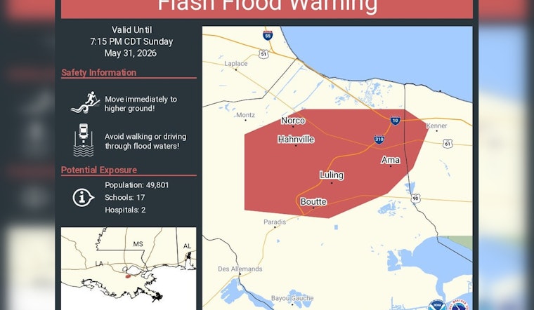
A flash flood warning was issued Sunday for parts of Jefferson and St. Charles parishes as thunderstorms dumped heavy rain across low-lying river communities west of New Orleans. Officials warned that pockets of rapid runoff and standing water on roadways could make driving hazardous through the evening.
National Weather Service in New Orleans/Baton Rouge listed the alert on its hazards page, and WWL‑TV reported that the NWS tweeted the warning covering communities including Luling, Destrehan and Saint Rose and that the warning was set to expire around 7:15 p.m. CDT. Local emergency listings showed advisories and flood statements extending into the evening as storms tracked across the metro.
Where flooding is most likely
Radar showed heavy, nearly stationary thunderstorms over sections of southeastern Jefferson and St. Charles parishes capable of producing very high rainfall rates in a short time. Local alert pages indicated between 0.5 and 1 inch had already fallen in spots, with another 1 to 2 inches possible, amounts that can overwhelm drainage and cause rapid street flooding, according to LocalConditions.com. Low-lying neighborhoods, underpasses and drainage challenged roads were flagged as the most vulnerable areas.
Safety and what to do
Officials urged residents to avoid driving through flooded streets and to move to higher ground if water begins rising. The National Weather Service's flood safety page reminds the public to "turn around, don't drown" and warns that even a few inches of fast moving water can sweep a vehicle from the road; see flood safety guidance from the National Weather Service for details.
Meteorologists advised people to monitor local forecasts as storms shift and to follow updates from emergency officials. For updated local coverage, see WWL‑TV.


