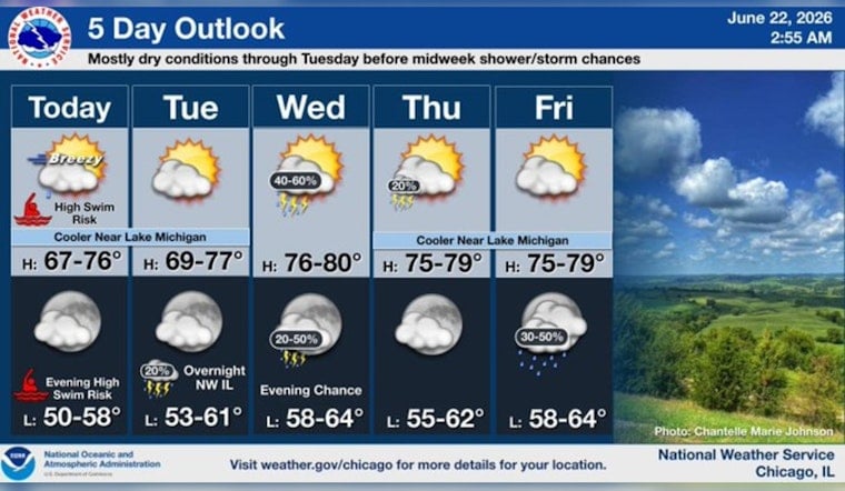
Chicago is waking up to a mostly cloudy, cool Monday morning with temperatures hovering near 59°F at city observation sites. Onshore winds are keeping lakeside neighborhoods noticeably cooler than inland spots. A Beach Hazards Statement and nearshore Small Craft Advisories are already up, and the lake is expected to stay rough through late tonight (Monday, June 22, 2026).
Beach Hazards Through Tonight
If your plans involve the shoreline, you might want a backup. Forecasters are calling for waves of 4 to 6 feet and dangerous currents along southern Lake Michigan beaches, and lifeguards may respond by posting warning flags or fully closing swim areas. Small-craft advisories are in effect for the nearshore waters, and officials are strongly urging people to stay out of the water and to steer clear of piers, jetties and breakwalls. These hazardous conditions are expected to continue through late tonight (Monday, June 22, 2026), according to NWS Chicago.
Afternoon Winds Pick Up
By this afternoon (Monday, June 22, 2026), north-northeast winds are forecast to run around 15 mph, with gusts up to 25 mph. That will keep the lake choppy and could send sand flying across the lakefront path. High temperatures should top out near 65°F, with inland areas briefly warmer once skies clear a bit. Cyclists and lakefront commuters are advised to build in extra time and to secure any loose items on balconies before the gusts ramp up.
Midweek Outlook
Conditions calm down on Tuesday, June 23, 2026, with dry weather and highs near 67°F. An upper-level trough arriving Wednesday, June 24, 2026, brings a higher chance of showers and thunderstorms Wednesday afternoon and evening, with a 50% chance of precipitation and highs rising into the upper 70s. More rounds of hit-or-miss showers and storm chances linger through the end of the week before a warmup arrives Sunday, June 28, 2026, when highs are expected to reach near 87°F. Forecasters at NWS Chicago have the latest timing details and active advisory information.


