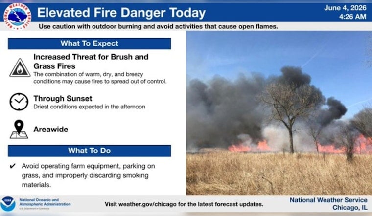
Chicago woke up to mostly sunny skies Thursday with temperatures in the mid 60s, and the warmup is not wasting any time. Forecasters expect highs near 88°F this afternoon as south-southwest winds ramp up to around 5-15 mph, with gusts up to about 25 mph during the hottest part of the day. The mix of warm, dry air and those gusty breezes is creating an elevated grass and brush fire risk across parts of the area.
Afternoon Winds Pick Up
Winds out of the south-southwest will strengthen through the morning and into the afternoon, leaving inland neighborhoods noticeably warmer than spots near the lake. The National Weather Service in Chicago has issued a Special Weather Statement, warning that relative humidity could drop to around 25 percent and that the warm, breezy setup will boost the risk for grass and brush fires. "Use extra care with any outdoor activities that involve open flame or sparks," according to NWS Chicago. Expect the strongest gusts from midday into the afternoon, when unsecured canopies and light yard gear are most likely to get tossed around.
Fire-Safety Basics
Avoid parking on dry grass, keep grills and mowers away from dead brush, and make sure smoking materials are completely out before you toss them. If you are running outdoor equipment, keep a hose, bucket of water, or fire extinguisher close by and hold off on burning or spark-heavy projects until humidity improves. Event planners should stake and tie down tents and lock in gas and grilling areas well before the windiest hours arrive.
Storms Return Friday Into Saturday
A plume of deeper moisture moves in late Thursday night into Friday, increasing the chance for showers and thunderstorms during the day Friday (June 5) and making showers and storms likely Friday night into early Saturday. Forecasters are calling for about a 70 percent chance of precipitation Friday and roughly an 80 percent chance Friday night, with stronger southwesterly winds of 10-20 mph and gusts up to around 30 mph possible. There is a low (1 of 5) severe-weather concern mainly Friday evening and night, with localized heavy rainfall or a few stronger storms in the mix, so keep an eye on updates from the National Weather Service, as noted by NWS Chicago.
Plan Ahead
Tie down tents and secure lightweight gear before the gusty afternoon window, and push any pile burns or open-flame projects to a time when humidity has recovered. If you have outdoor plans Friday night, line up a backup indoor spot, since showers and thunderstorms are likely and could deliver brief heavy rain. See our earlier forecast for the background on the warmup earlier forecast.
Bottom line: enjoy the sunshine, but use extra caution with anything that could spark a fire, and check the latest updates from local officials and the National Weather Service before heading out. We will update this post if conditions change.


