

























































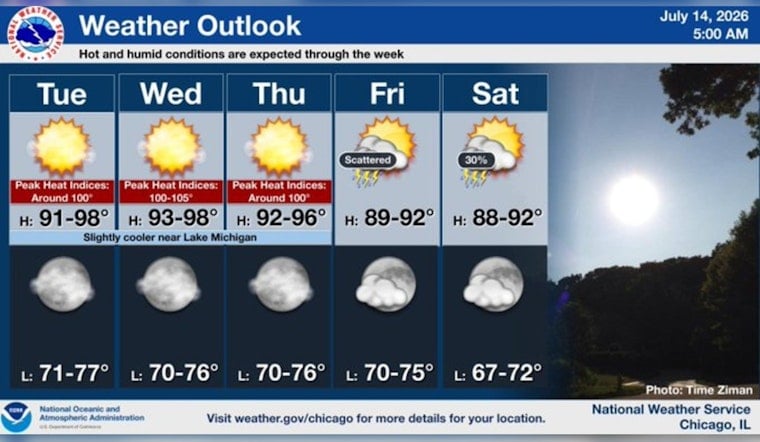
Chicago is waking up to a thick, soupy start Tuesday, with early readings around 73°F (23°C) and dew points in the low 70s making it feel downright sticky. Sunshine will rule the day and temperatures are expected to surge to about 91°F, with heat-index values this afternoon topping out near 95°F.
Hot stretch through midweek
The heat does not tap the brakes on Wednesday. Inland spots are projected to climb into the mid-90s, with peak “feels like” readings near or above 100°F. The National Weather Service Chicago is calling for highs near 94°F on Wednesday and warns that heat-index values could reach around 101°F, while overnight lows only slip into the mid-70s, offering very little cooldown. Forecasters note that if the higher heat-index values become more widespread, a heat advisory or warning may be issued.
Air quality alert in effect
An Air Quality Alert is posted through Tuesday night after the Illinois EPA declared an Air Pollution Action Day for the greater Chicago area. The alert signals that ozone or particle levels could rise into the “Unhealthy for Sensitive Groups” range, meaning active children, older adults, and people with asthma or other lung conditions should dial back prolonged or intense time outside. For current AQI readings and health guidance, check the Illinois EPA.
Lakefront relief will be limited
Lake Michigan will try its best, but the lake breeze only offers patchy relief right at the shoreline. Temperatures are expected to jump quickly once you are more than about a mile inland, so most neighborhoods stay firmly in the hot zone. Look for the coolest readings at the immediate water’s edge and the hottest in deeper inland areas, with many spots holding in the mid-70s overnight.
Storm chances later this week
There is a slight shot at showers and a few isolated thunderstorms Thursday afternoon, with a better chance for scattered storms Friday and into the weekend. The National Weather Service Chicago currently shows precipitation chances climbing into the 40 to 50 percent range on Friday. Any storms that do fire up could be slow movers with brief heavy downpours or gusty winds, so it is worth keeping an eye on updated forecasts for the timing.
How to prepare
Hydrate frequently, skip strenuous outdoor activity during the peak heat of the afternoon, and spend time in air-conditioned spaces when you can. If you or someone you look after is sensitive to heat or poor air quality, call 3-1-1 or use the city’s cooling-centers map to find an air-conditioned location, and check local forecasts and AQI updates before committing to long stretches outside.





