

























































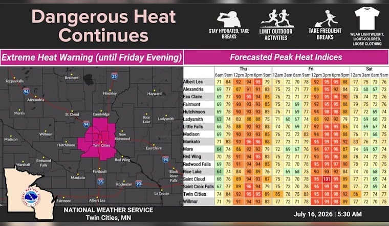
Minneapolis is waking up under a thick blanket of wildfire smoke Thursday, with skies turned milky gray, visibility at Minneapolis-St. Paul International Airport cut to roughly 2 miles, and air quality landing in the hazardous range. Morning temperatures in the lower 70s are expected to surge into the low 90s, with a high near 936F and heat-index values pushing into the mid 90s by afternoon. An Extreme Heat Warning covers the Twin Cities metro through 9 p.m. Friday, and an Air Quality Alert is in place into Friday morning, raising serious health concerns and putting outdoor plans on the chopping block.
Hazardous Air Quality And Health Precautions
The Minnesota Pollution Control Agency has issued an Air Quality Alert for central Minnesota and the Twin Cities and warns that fine-particle pollution from wildfire smoke could climb into the Maroon (Hazardous) category. Sensitive groups are urged to stay indoors and keep physical activity to a minimum. According to the Minnesota Pollution Control Agency, dense smoke is cutting visibility and has led to reports of ashfall in some locations. Anyone with lung or heart disease, asthma, very young children or older adults is advised to avoid outdoor activity and to keep windows closed overnight.
Heat And Timing
The National Weather Service is calling for highs near 936F today with heat-index readings around 966F, followed by an even hotter Friday with highs close to 966F and heat-index values that could reach 1006F. Overnight lows in the lower 70s will not offer much relief, which increases cumulative heat stress for people who do not have access to air conditioning or other cool indoor spaces. Per the NWS Twin Cities, the Extreme Heat Warning remains in effect for metro counties through 9 p.m. Friday.
Commute And Event Impacts
Thick haze and reduced visibility may slow the morning commute and make driving feel more like a slog than a sprint. The smoky air and oppressive heat could also force postponements or venue changes for outdoor events, especially youth sports, practices and community festivals. Officials recommend delaying strenuous outdoor work when possible, taking frequent cool-down breaks if you must be outside and never leaving children or pets unattended in a vehicle, even for a short time.
For anyone who needs a place to cool off, many libraries, community centers and nonprofit facilities open as temporary cooling locations during heat events. Residents can call 2-1-1 to find a nearby site.
Looking Ahead
Forecasters expect the thickest smoke to gradually retreat northward while the heat briefly intensifies on Friday. A frontal system is forecast to arrive late Sunday night into Monday morning, bringing the next round of rain, with showers and thunderstorms likely. That system could deliver gusty west winds, with National Weather Service forecasters noting gusts up to about 30 mph Monday, along with a roughly 60% chance of precipitation in the metro. Temperatures should slide back into the low 80s by midweek, easing the immediate heat concerns.
Over the next 48 hours, the playbook is simple: stay hydrated, spend time in cool, filtered air when you can and check on neighbors, friends or family who may not have air conditioning. Keep an eye on updated advisories from the National Weather Service and the Minnesota Pollution Control Agency and be ready to tweak outdoor plans as conditions change.



