

























































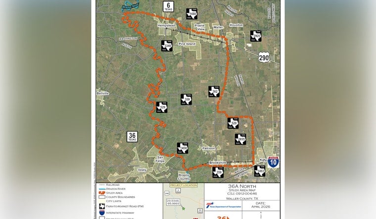
State highway planners have put five possible routes on the table for the northern leg of Highway 36A, a proposed 20 to 25 mile corridor that would connect I-10 west of Katy to U.S. 290 west of Waller. The Texas Department of Transportation is asking the public to weigh in, following a pair of scoping meetings this week, and will keep the written comment period open through July 31, 2026. Officials say the goal is to ease congestion and give commercial trucks a more direct line between the Port of Freeport and major northbound highways.
What TxDOT Is Proposing
According to TxDOT, the 36A North segment would span roughly 20 to 25 miles, with four main lanes in each direction divided by a grassy median. The concept includes intermittent frontage roads where traffic demand calls for them, along with drainage features designed for the corridor.
TxDOT also proposes dedicated space for people who are not behind the wheel. Plans call for a 10 foot shared-use path for pedestrians and cyclists running alongside the highway. Draft study-area maps and technical reports are posted by the project team for residents to review before they send in comments.
Why It Matters
Local leaders have pitched the corridor as a pressure valve for the region's traffic and a straighter shot for heavy trucks hauling between Port Freeport and the big north-south routes, a point Fort Bend County Commissioner Andy Meyers discussed with Community Impact. The outlet also notes that the southern stretch of 36A is under review through eight possible alignments, underscoring that this is a multi-county puzzle, not a quick sketch on a map.
Supporters say a new corridor could pull truck traffic off local roads. Skeptics are already eyeing the flip side: potential property acquisition and environmental impacts that will have to be spelled out in detail.
Public Meetings And How To Comment
The formal federal notice for the Environmental Impact Statement lays out one virtual scoping meeting and two in-person open houses, each scheduled from 5 to 7 p.m., and invites public feedback, according to the Federal Register. The in-person sessions are set at the Royal ISD Early Childhood Center in Brookshire and Edmonds Hall at the Waller County Fairgrounds in Hempstead.
The same notice includes instructions for written comments. Residents can mail input to Advanced Project Development, TxDOT Houston District, P.O. Box 1386, Houston, TX 77251-1386, or email [email protected]. The deadline to speak up on the record is Friday, July 31, 2026. Project staff say map-based tools and an interactive comment map have been posted with the scoping materials so people can line up the alternatives on screen and drop location-specific feedback.
Timeline And Next Steps
Project documents show TxDOT plans to carry the 36A North options through a full Environmental Impact Statement process, with a final route for the northern section expected in late 2029 and a final alignment for the southern section anticipated in 2028, according to TxDOT. Between now and a draft EIS, engineers and environmental specialists will narrow down the choices, run traffic and environmental analyses, and hold public hearings.
Actual construction money is a separate question. Funding has not been identified and would come only after the planning work and environmental clearance are complete.
What Residents Should Watch For
Beyond the big-picture maps and lane counts, property owners will want to track right-of-way notifications, draft environmental findings, and early coordination letters that spell out potential effects on homes, farms, and natural areas. The Federal Register notice makes it clear the EIS will study several build options along with a no-build alternative, and that cooperating agencies will be invited to join the review.
For now, the key action items are the posted scoping materials and the July 31 comment deadline. Anyone who wants to praise the concept, blast it, or nudge the lines on the map has a formal window to get those thoughts into the record.





