

























































Minneapolis is waking up to light rain, fog and a stubbornly gray sky Friday, with showers expected to continue through much of the day. Temperatures will stay cool for late July, hovering near 70 degrees before reaching only about 73, while the weekend is already shaping up to be a much brighter reset.
Rain Lingers Through Friday Afternoon
Rain will be most persistent through the morning and early afternoon, with the chance of showers gradually easing later Friday. East-northeast winds will run 5 to 15 mph, with gusts up to 30 mph possible, and new rainfall amounts in Minneapolis could range from a quarter-inch to a half-inch.
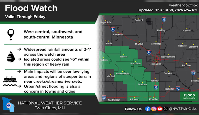
The broader storm system is producing its heaviest rain across southwestern and southern Minnesota. The National Weather Service says some areas near the Minnesota River could receive 2 to 4 inches, with locally higher totals, while the southwest portion of the Twin Cities metro has the better chance of approaching an inch.
Flood Concerns Favor Areas South And West
A Flood Watch remains in effect Friday for several counties south and west of Minneapolis, with most of the watch ending around noon and the southernmost counties covered into the afternoon. Minneapolis is not listed in that watch, but drivers should still watch for ponding water, reduced visibility and slower travel during the morning commute.
Sunny Skies Return For The Weekend
Friday night should turn mostly cloudy and cooler, with a low near 62 and patchy fog possible early Saturday. Saturday will then become sunny and reach about 84 degrees, followed by a clear night near 63.
Sunday looks similarly pleasant, with sunshine, a high near 82 and a low around 64. Monday should stay sunny and warmer near 85 before a slight chance of showers and thunderstorms returns late Monday night into Tuesday, when highs will settle in the lower 80s.




