

























































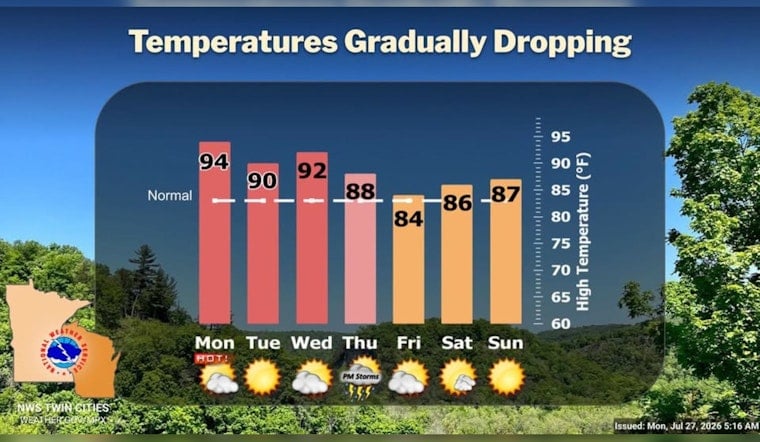
Wednesday, July 27 is coming in hot for Minneapolis, with early readings already in the low 80s and overnight humidity hanging on. Forecasters expect temperatures to climb into the low to mid 90s this afternoon, and the city is under a Heat Advisory through 8 p.m. The most oppressive conditions are expected during the mid to late afternoon commute, when streets and buses will feel like moving ovens.
Afternoon Heat
High temperatures are forecast to top out near 94°F, with the heat index pushing into the upper 90s and in a few spots flirting with 100. According to the National Weather Service Twin Cities, the Heat Advisory remains in effect until 8:00 p.m. CDT for Hennepin County and surrounding areas, and residents are urged to avoid long stretches of outdoor exertion, stay hydrated and keep an eye out for signs of heat illness. West-northwest winds around 5 to 15 mph will occasionally gust during the peak heating hours, which may stir the air a bit but will not do much for actual relief.
Cooling Options
For anyone without dependable air conditioning, the plan today should involve a few hours in an air-conditioned public space, not toughing it out on the couch. Libraries, recreation centers and designated cooling sites are available throughout the city. The City of Minneapolis provides a list of cooling centers along with heat safety tips, and officials recommend checking those details before heading out. Neighbors are also urged to look in on older adults, people with medical conditions and pets during the hottest part of the day.
Patchy Smoke And What It Means
On top of the heat, elevated smoke from western wildfires is expected to drift in after late morning, creating patchy haze that could cut visibility and irritate people with sensitive lungs. Forecasters say the smoke might take a bit of the edge off the direct sunshine, but it is not expected to be strong enough to keep temperatures from climbing into the 90s. Dew points should slip into the 60s this afternoon, which could make it feel a touch less soupy than it did overnight. These trends, along with a late week chance for showers and thunderstorms, are outlined by the National Weather Service Twin Cities.
Looking Ahead
The hot pattern is expected to hold through midweek, with another warm one on tap for Wednesday, before increasing moisture and a passing disturbance bring a better chance for showers and thunderstorms from Thursday night into Friday. Some of those storms could drop heavy rain. Anyone with outdoor plans later in the week is advised to keep an eye on updated forecasts and shift events away from the most punishing heat or any potential severe weather windows.





