

























































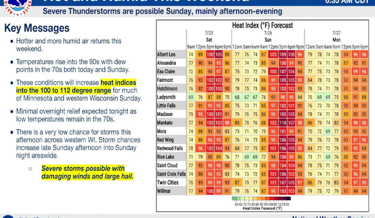
Minneapolis woke up to low clouds and sticky humidity Saturday, July 25, and the Twin Cities are staring down a dangerous stretch of heat. Highs are expected to reach around 94°F today and roughly 97°F on Sunday, July 26, with heat-index values, essentially what it feels like on your skin, climbing into the triple digits. Overnight lows stuck in the mid to upper 70s will leave little chance for the city to cool off, so if you have to be outside, aim for early morning or later in the evening.
Dangerous Heat Warning And When It Peaks
The National Weather Service has issued an Extreme Heat Warning for metro counties starting around noon Saturday and lasting through Sunday evening, with the hottest window expected Sunday afternoon. Forecasters say heat-index values could reach 100 to 110°F in parts of the metro, which significantly raises the risk of heat exhaustion and heat stroke for anyone working or exercising outdoors. Light west-southwest winds and warm nights mean very little natural relief, a combination that is especially dangerous for vulnerable residents.
City Resources And How To Stay Safe
The City of Minneapolis is urging residents without home air conditioning to spend time in air-conditioned public spaces such as libraries, recreation centers, and community buildings, which are listed along with safety tips on the city's heat information page. Officials stress not leaving children or pets in vehicles and avoiding heavy exertion during the afternoon hours. Residents are encouraged to check on older neighbors and people with medical conditions. Outdoor workers should bring plenty of water, take frequent breaks in the shade, and follow their employer's heat safety rules.
Storm Chances And What Could Change
A weak front could trigger a few showers or thunderstorms from Sunday evening into Monday, and any storms that do fire could bring brief relief from the heat. Forecasters caution that storm development is uncertain, and if storms do organize they could come with sudden wind gusts or heavy downpours, so it is smart to have a plan to move indoors quickly. If storms stay limited, the Twin Cities should expect hot, mostly dry conditions to continue into midweek with highs holding in the low 90s.





