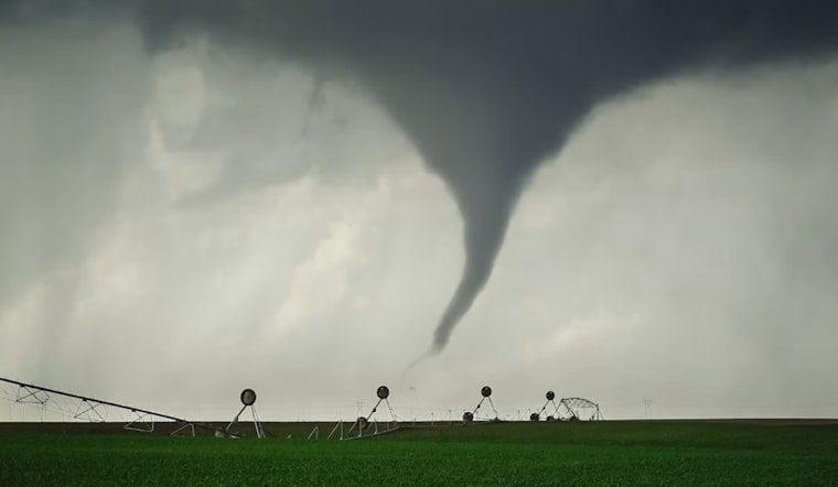
Yesterday's thunderstorm in Michigan’s central Upper Peninsula left behind splintered trees, dinged-up roofs and a big meteorological question: did a tornado actually touch down near Trenary, or did radar make it look worse than it was?
National Weather Service crews spent today in the field across the central U.P., inspecting tree and roof damage after a severe storm that showed rotation on radar and dropped unusually large hail. The storm tracked northeast along U.S. 41 between Trenary and Rapid River at roughly 7:14 p.m. local time, and residents in scattered rural pockets reported downed branches and broken limbs. Officials have not yet confirmed a tornado touchdown, and a formal damage survey is underway to determine whether the radar-indicated rotation produced a brief touchdown.
What the weather service warned
The National Weather Service issued a tornado warning for north-central Delta County and southwestern Alger County Tuesday evening, saying radar showed rotation and that the storm could produce a tornado and damaging hail. The warning placed the storm near U.S. 41 between Trenary and Rapid River around 7:14 p.m. EDT and urged people in mobile homes and other vulnerable structures to take cover, according to the National Weather Service.
Survey and hail reports
In an email to reporters, a National Weather Service official said, "We have staff conducting a survey this morning (July 1) to determine if a tornado touched down and caused damage," and crews were working Wednesday to map any damage paths. Local storm reports logged large hail, with two 1.5-inch reports in the Trenary area and a 0.88-inch report at Au Train as the line moved across the U.P. These details were reported by the Detroit Free Press.
Warning text and radar notes
The tornado warning product described a severe thunderstorm capable of producing a tornado near U.S. 41 between Trenary and Rapid River and specifically referenced radar-indicated rotation and the potential for hail and flying debris. The raw warning text archived by public-warning aggregators reproduces the National Weather Service wording about radar-observed rotation during the 7 p.m. hour. For the original warning language, see an archived product of the warning text via Tornado HQ.
How unusual would this be?
Tornadoes are uncommon in Michigan’s Upper Peninsula. If the survey confirms a touchdown, it would be the first tornado confirmed in the U.P. since 2020, when National Weather Service damage surveys recorded two EF-1s and an EF-0 across parts of the peninsula. That 2020 activity was notable for snapped and uprooted trees rather than widespread structural collapse, records show. The historical context was reported by the Detroit Free Press.
Next steps and how residents can help
National Weather Service survey teams will continue mapping any damage, photographing evidence and comparing ground impacts with radar to determine whether tornadic winds, rather than straight-line gusts, caused the observed damage. The office asks anyone with photos, videos or damage reports to pass them along through their local National Weather Service office’s storm report page so the survey has as much on-the-ground information as possible. Local emergency managers will coordinate power restoration and cleanup if needed, per guidance from the National Weather Service.


