

























































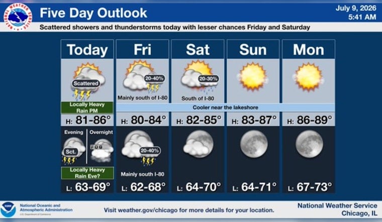
The day starts steamy in Chicago, with mostly clear skies, muggy air, and temps lingering in the low 70s near Midway. That quiet vibe will not stick around for long. From mid-morning through the afternoon and into this evening, scattered showers and thunderstorms are expected to fire up, bringing brief but intense downpours and some gusty winds. The high should land near 82°F, and anyone heading out this afternoon should plan for a potentially soggy commute, especially in blocks that flooded last weekend.
Scattered Storms This Afternoon And Evening
A few isolated showers could pop up by mid-morning, with more organized scattered thunderstorms developing by early afternoon and continuing through the evening. Temperatures are expected to top out near 82°F, with west-southwest winds around 5–10 mph. Many spots may pick up a quarter to a half inch of rain, while stronger cells could briefly unload an inch or more per hour and kick up gusts of 40–60 mph.
Overnight, the bulk of the storm activity may sag to the south and east, but a boundary off the lake could nudge back inland later tonight, setting the stage for patchy, locally dense fog. Those timing and impact details come from the National Weather Service.
Flooding Risk Where Ground Is Saturated
With many neighborhoods still soggy from last weekend’s storms, even short-lived but intense downpours could quickly overwhelm streets and seep into basements again. The city’s deep-tunnel system and nearby reservoirs pushed toward capacity during the earlier deluge, leaving some areas more vulnerable, according to Axios Chicago.
If you live on a low-lying block, give yourself options: avoid driving through standing water, document any damage for insurance, and call 3-1-1 to report flooding or downed trees.
Tonight's Fog And Weekend Outlook
Once storms move out, a cooler boundary off the lake may settle inland late tonight, potentially bringing MVFR to locally dense fog into Friday morning. Early commuters should budget extra travel time and be ready for reduced visibility.
The rest of the weekend looks more cooperative: generally drier and warmer, with highs in the mid- to upper-70s Saturday and climbing toward the upper 80s to around 90°F by early next week. Outdoor plans are still fair game, but it is worth keeping an eye on radar and local forecasts, since training storms can change conditions in a hurry.
Practical moves for today: secure loose outdoor furniture, allow extra time for the drive, and avoid flooded streets. Turn around instead of driving through standing water. If flooding does hit your block, photograph any damage for claims, call 3-1-1 to report it, and keep monitoring local alerts and the National Weather Service for updates and radar imagery.





