

























































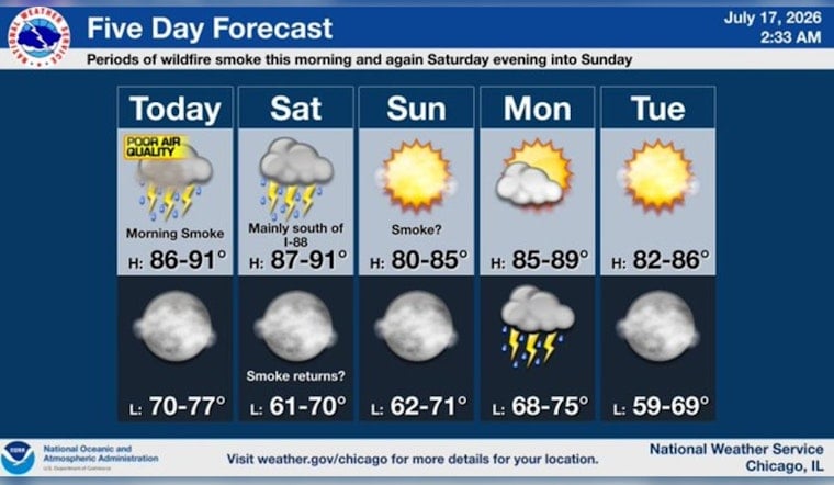
Chicago woke up Friday, July 17, 2026, to a murky sky that looked more like late August in wildfire country than a mid-July morning on the lakefront. Hazy smoke hung over the city, visibility dropped in parts of the metro, and an Air Quality Alert kicked in for much of northern Illinois and northwest Indiana. Temperatures started in the upper 70s and are expected to climb toward 90 degrees this afternoon, with heat-index values in the mid 90s and a shot at scattered showers or thunderstorms into the evening.
Afternoon Storms And Timing
The smoky veil is expected to linger through mid-morning, but the real atmospheric drama comes later. Scattered showers and storms are forecast to bubble up by mid to late afternoon and roll into the early evening. Storm coverage is roughly 30 to 60 percent today, and any storm that pops could bring brief heavy downpours and gusts to 15 to 30 mph, enough to trigger localized street ponding in the usual trouble spots. Most of the action is favored near and east of I-55, while inland neighborhoods are likely to stay hottest and most humid, according to the National Weather Service Chicago.
Air Quality And Health
The Illinois Environmental Protection Agency has issued a Red Forecast Air Pollution Action Day for Friday, and early readings landed in the “hazardous” range in some locations. Everyone, especially children, older adults, and people with heart or lung conditions, is urged to cut back on prolonged outdoor exertion and avoid heavy outdoor activity today. Before lacing up for a run or sending kids outside to play, check your neighborhood AQI and NowCast updates on AirNow.
Plan Your Day
If your Friday plans involve a park, patio, or ballfield, it might be a good day to shift at least part of the action indoors or scale back the most strenuous pieces to limit smoke exposure. Outdoor workers should take frequent breaks inside and follow employer safety guidance. If you do not have air conditioning, keeping an eye out for local cooling centers or indoor public spaces could make the afternoon a lot more bearable. Along the lakefront, beaches may see stronger northerly gusts this weekend, and lifeguards and park officials will post advisories if water conditions turn hazardous.
Looking Ahead
A cold front is set to sweep through on Saturday, keeping highs near 90 degrees while cranking up the thunderstorm threat. Areas near and south of I-80 carry the highest chance for strong to potentially damaging storms, with the main concern being damaging downburst winds. Forecasters outline a small to marginal severe risk on Saturday, and heat indices may still push close to 100 degrees before the front arrives. High pressure should settle in on Sunday with drier, sunnier weather, although forecasters warn that another plume of smoke may ride in behind Saturday’s front and temporarily knock air quality down again. Another round of showers and storms is possible early next week as systems move back into the Great Lakes.
For more on how this smoky setup developed and earlier alerts, see our previous coverage, Smoky Skies Choke Chicago. We will update this piece if the Air Quality Alert is extended or storms are expected to pose a local threat.





