

























































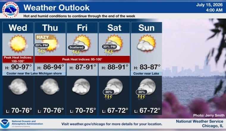
Chicago is waking up sweltering on Wednesday, July 15, 2026, with hot, humid and noticeably hazy air already hanging over the city. Early-morning readings are near 77°F with dew points in the low 70s, leaving much of the metro feeling sticky. The National Weather Service expects a high near 92°F, with afternoon heat index values pushing into the upper 90s.
Afternoon Heat And Humidity
Most neighborhoods will see plenty of sunshine and a light north wind around 5 mph, with inland spots running a few degrees warmer than the lakefront. Highs should top out near 92°F, and the heat index will make it feel more like the upper 90s. Overnight lows are expected to sink only into the mid 70s, so the city may not get much of a cooldown. If you are doing outdoor work or exercising, it is worth taking breaks and avoiding the mid-afternoon peak.
Smoke And Air Quality
An Air Quality Alert is in effect for the Chicago metro through midnight Wednesday night (12:00 a.m. CDT Thursday, July 16), and the Illinois EPA has declared an Air Pollution Action Day. The alert advises that "active children and adults, especially people with pulmonary or respiratory disease such as asthma, should limit prolonged outdoor activity." Low level smoke from Canadian wildfires is forecast to surge south into northeast Illinois by Thursday morning and could reduce visibility, especially north and east of a Rochelle to Valparaiso line, according to the National Weather Service in Chicago.
Where To Find Relief
If you do not have reliable air conditioning, public cooling centers and Park District facilities offer air-conditioned rooms. The Chicago Park District lists cooling center locations. You can also call 311 for help finding a nearby site. In the meantime, hydrate, check on neighbors and go easy on strenuous outdoor activity during the late afternoon heat.
Looking Ahead
Hot conditions are expected to stick around through the rest of the week, with highs generally in the upper 80s to low 90s and overnight lows in the 70s. There is a slight chance of showers or isolated storms Thursday, with storm chances increasing Friday and again late Saturday into the evening when heavier showers are possible. Sunday should trend a bit cooler, with highs near the low 80s.





