Wednesday, July 1, 2026, is starting out sticky in Minneapolis, with about 73°F at MSP, dew points in the upper 60s and mostly clear skies early. A fast-moving line of thunderstorms is racing northeast into the region and is expected to bring gusty winds and heavy downpours from the late morning into the afternoon. Commuters and anyone with outdoor plans should be ready to pivot quickly as sudden bursts of rain roll through.
Morning Line And Timing
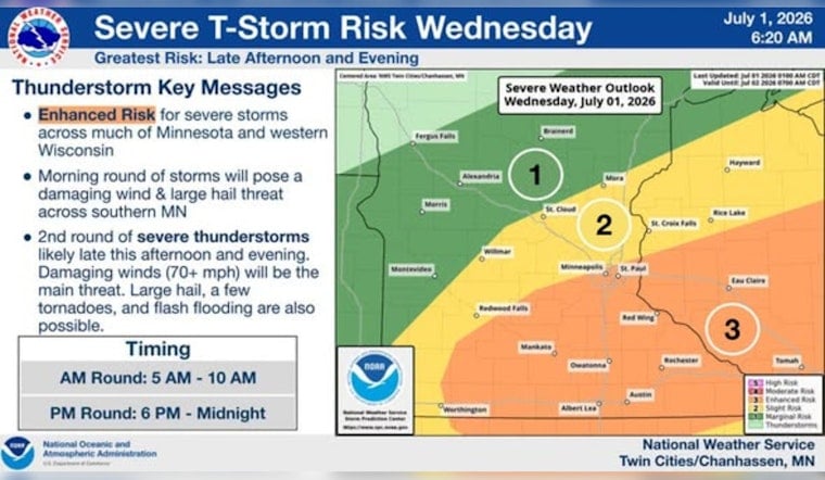
A broken line of storms will sweep across the metro this morning, with the main window from late morning into the early afternoon. The National Weather Service is flagging the initial band for strong wind gusts, locally up to 50–60 mph, along with brief but intense rainfall that will cut visibility and make roads slick. Rainfall in this first wave is generally expected to land between a quarter and a half inch, though heavier pockets are possible in spots, according to the National Weather Service Twin Cities.
Afternoon And Tonight
Storms are expected to fire up again across southern Minnesota and western Wisconsin this afternoon and may linger into the evening and overnight hours. Late-day cells carry the risk for large hail, damaging wind gusts and training storms that could stack up pockets of heavy rain. Isolated totals of several inches are possible where storms stall. If you have evening plans, keep an eye on updated warnings, since the overnight period carries an elevated flash-flood risk in some areas.
Travel And Events
Travel could get messy on both the roads and transit. Replacement buses are already running on parts of the Green Line through July 26, and any severe storms can stretch those delays even longer. Check service notices before you head out, as Metro Transit posts updates in real time for riders.
What To Do
Have a wet-weather backup ready for outdoor plans and make sure you can receive real-time alerts on your phone. If you are driving, slow down in heavy rain, avoid standing water and secure loose outdoor items before the gusty winds move in.
Forecast At A Glance
Highs today should reach near 84°F with a low near 69°F tonight. Thursday is expected to warm toward 90°F with drier skies. Additional rounds of storms are possible later this week, with Friday guidance still showing a chance for locally heavier rainfall totals in some locations.


