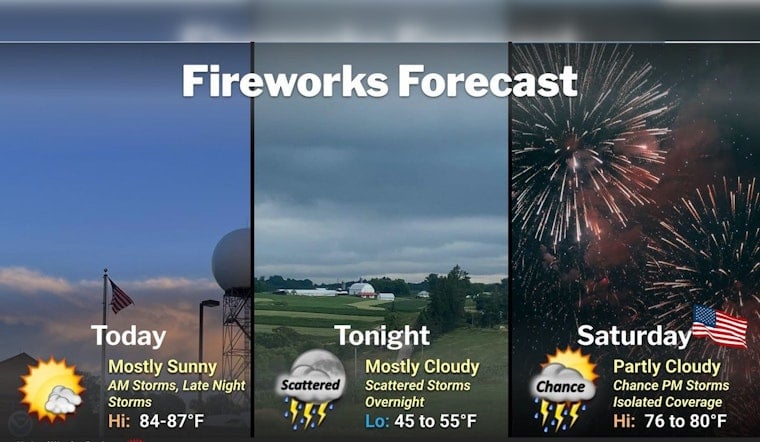
Minneapolis woke up to a blanket of humidity Friday, July 3, with skies mostly cloudy and the air feeling more like a sauna than a summer morning. Readings at the airport are sitting in the upper 60s to around 70F, and dew points are hovering in the upper 60s, making it feel every bit as sticky as it sounds. South-southeast winds are running light to moderate, and a few scattered showers or isolated thunderstorms could drift through this morning. By afternoon, expect highs topping out in the mid-80s.
Timing And Impacts
Through midafternoon, there is a 30 to 60 percent chance of showers and thunderstorms, and any storm that pops up could deliver an isolated downpour. That means a quick hit of heavy rain that may briefly cut visibility on area roads. Another round of storms is possible tonight, with the main concerns being heavy rain and brief gusty winds. A few neighborhoods could easily pick up several tenths of an inch of rain. That outlook comes from the National Weather Service.
Holiday Travel And Transit
Independence Day on Saturday, July 4, looks like a classic Midwestern mug-fest, with repeated chances for storms and a high in the low 80s. Where storms line up, new rainfall totals of about a quarter to a half-inch are on the table. The transit agency Metro Transit says it will run reduced service on Friday, July 3, and holiday service on July 4, so riders should double-check schedules before heading out. If you are planning to catch fireworks or fire up the grill, keep a dry backup plan in your back pocket and be ready for last-minute adjustments.
Plan Ahead
For the commute, it is smart to budget extra travel time and steer clear of standing water, since brief heavy showers can make surface streets slick in a hurry. A rain jacket will not be overkill, and keeping outdoor plans flexible is a good idea, especially this evening and overnight when the heavier storms are most likely to roll through.
Looking Ahead
Once the holiday is in the rearview mirror, a short lull in the action is expected early next week before heat and humidity crank back up by midweek. Highs should climb into the upper 80s again, with another round of possible afternoon showers on the horizon. If you have plans later next week, keep an eye on updates through the weekend so the weather does not catch you off guard.


