

























































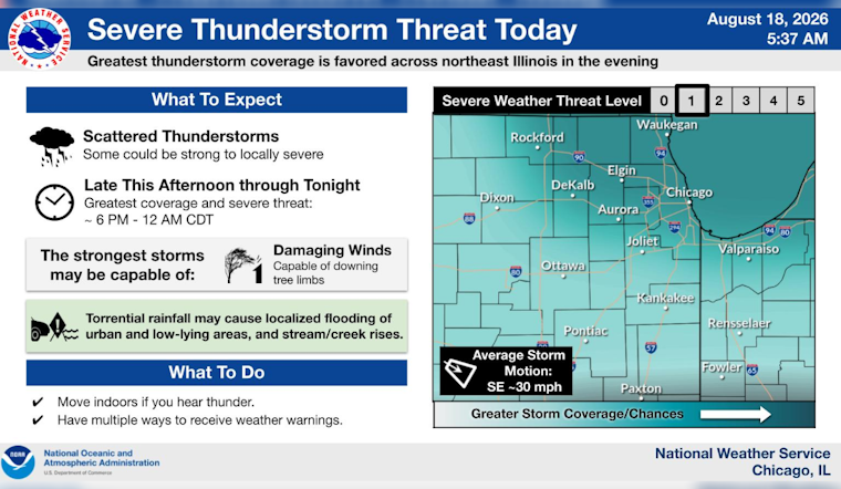
Chicago is starting Tuesday with clear skies and temperatures around 66 degrees, but the calm opening is a short one. The city should warm to near 80 under partly sunny skies before showers and thunderstorms become possible from early afternoon into the evening. The biggest concern is not an all-day washout but a few storms capable of producing strong winds and quick downpours.
A slight chance of showers arrives between 1 and 3 p.m., with thunderstorm chances increasing from roughly 3 p.m. onward. Southwest winds will run 10 to 15 mph, with gusts reaching up to 25 mph, according to the National Weather Service Chicago.
Storms Could Complicate The Evening
The more organized storm threat is expected from about 5 to 10 p.m., though showers and thunderstorms could linger into the overnight hours. Forecasters say some storms may bring damaging wind gusts and heavy rainfall, with roughly a quarter- to half-inch of rain possible in spots and localized flooding if storms track over the same areas.
No watches, warnings or advisories are listed for the area at this time. Anyone heading out Tuesday evening should keep an eye on radar, move indoors when thunder is heard and avoid driving through water-covered streets.
A Cooler, Quieter Midweek
Wednesday brings a noticeable reset, with mostly sunny skies and a high near 74 degrees. Thursday should be sunny and near 76, while Friday stays mostly sunny with a high around 78.
The cooler stretch comes with lighter winds and lower rain chances, offering a much easier forecast for outdoor plans after Tuesday’s storm window. Friday night and Saturday bring another chance of showers and thunderstorms, with Saturday’s high near 78.
Sunday And Monday Look Mostly Pleasant
Sunday is expected to turn sunny with a high near 75, followed by a partly cloudy night near 64. Monday should remain mostly sunny and reach about 76 degrees, keeping the broader outlook comfortable even with a few storm chances returning late in the week.





