

























































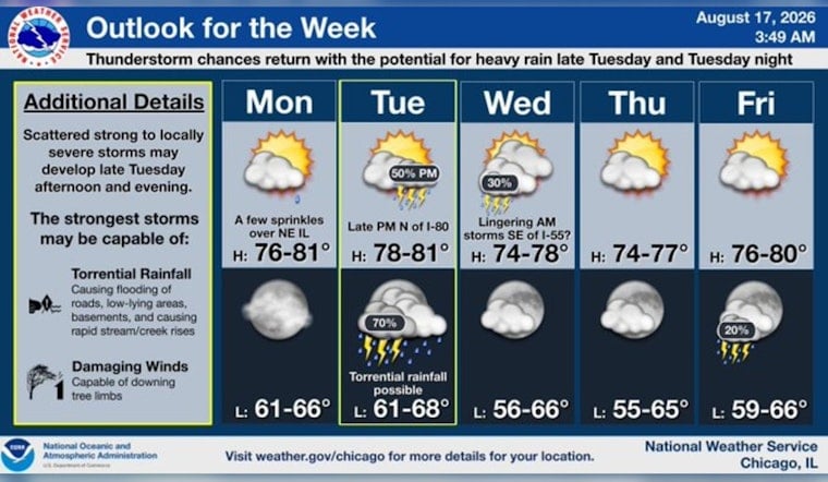
Chicago is getting a brief weather breather Monday, with clear skies early, a high near 74 degrees and only isolated rain showers possible through the afternoon. The cooler, less humid setup will not last long: Tuesday brings warmer air and a renewed chance for thunderstorms, including a risk of severe weather and flash flooding.
Monday Stays Cool With A Few Showers
Temperatures near the lake and across downtown Chicago should remain in the low to mid-70s, with north-northeast winds around 5 to 10 mph. The chance of rain is 20%, and most of the city is expected to stay dry even if a few light showers or sprinkles develop.
Monday night turns mostly clear, with winds easing and temperatures dipping to around 65 degrees. The National Weather Service says no watches, warnings or advisories are currently in effect for the area.
Tuesday Brings The Week’s Main Weather Concern
Tuesday will be warmer, with mostly sunny skies early and a high near 80 before showers and thunderstorms become possible after 1 p.m. Winds from the west-southwest could gust up to 20 mph, while the daytime rain chance rises to 40%, according to the National Weather Service.
The bigger concern arrives Tuesday evening and overnight, when thunderstorms are likely and the rain chance reaches 70%. Some storms could become severe, and repeated thunderstorms over the same areas could produce localized flash flooding, so outdoor plans and evening travel may require close attention to updated forecasts.
Cooler And Calmer Weather Returns Midweek
A few showers or thunderstorms could linger Wednesday morning before skies turn partly sunny, with a high near 75. Thursday looks mostly sunny and mild near 74, followed by another mostly sunny day Friday with a high around 78.
The weekend looks generally comfortable but not completely dry. Saturday could bring afternoon showers and thunderstorms, while Sunday turns mostly sunny with a high near 74.




