

























































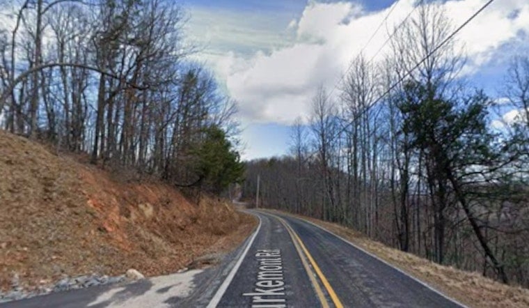
A block retaining wall gave way near Hidden Hill Venue on Burkemont Road sometime between 1 p.m. and 1:15 p.m. on Friday, triggering a landslide that officials say threatens the only route in and out of a stretch of southern Burke County. The wall collapsed after a line of heavy morning rainstorms swept through the area, and while the roadway itself remained passable into Friday evening, county officials say it would not take much more rain to change that.
The timeline of the collapse comes from Catawba Valley News & Weather, which reported the wall failure directly followed the morning storm line and noted the road stayed open through the evening. According to Queen City News, Burke County officials say Burkemont Road remains passable for now but could become limited or impassable near Hidden Hill Venue if conditions worsen. The outlet reports that rainfall was expected through midnight, and that additional rain could cause further movement of the slide into the roadway.
Why a Half-Inch of Rain Matters
Burke County Emergency Management has warned that as little as 0.5 inches of additional rainfall could trigger further slope movement or cause additional retaining wall failures, according to WSOC TV. Local officials emphasized to the station that Burkemont Road is the only access road serving residents living west of the collapse site, a point Queen City News also confirmed, reporting the roadway provides the sole means of reaching the area west of the landslide.
Per Queen City News, Burke County Emergency Management and the Burke County Fire Marshal's Office are both on scene, coordinating with the North Carolina Department of Transportation and other response partners. The outlet reports that if conditions worsen, those response partners will coordinate further, and that residents could experience delays in emergency response into or out of the area while the situation is monitored.
A Venue Built on Elevated, Recently Modified Ground
Hidden Hill Venue sits at 6572 Burkemont Road at an elevation of 2,539 feet, an 11-acre estate anchored by a 4,790-square-foot event barn built in 2017, according to property listing details from Lake Norman Realty. It operates as a high-capacity wedding destination in southern Burke County, situated directly above the stretch of road now threatened by the slide.
Property records published by Zillow show the site underwent modifications in 2024, including new underground drain pipes, fresh sod across 40 percent of the front yard, an extended patio, and driveway sealcoating. Proper water drainage is considered critical to maintaining hillside stability, and the presence of those upgrades offers relevant context for a property perched above a roadway now facing renewed slope movement.
A Road With a History of Getting Cut Off
Burkemont Road, officially State Road 1956, functions as a primary rural corridor providing access to the South Mountains region, including South Mountains State Park and South Mountains Game Land in southern Burke County. Mountain roads in this terrain generally lack immediate secondary detour options, which is part of why officials are watching the slope so closely.
This is not the first time the corridor has been disrupted by an environmental emergency. In July 2024, a 60-acre uncontained wildfire burned on Burkemont Mountain within 300 feet of Hidden Hill Venue, forcing emergency agencies to restrict Burkemont Road to residents only and set up water shuttle operations, as reported by The Paper. That response required coordination between local fire departments and the N.C. Forest Service.
Burke County's Broader Landslide Risk
The Friday collapse fits into a much larger pattern of instability across the region. The North Carolina Geological Survey, part of the state Department of Environmental Quality, maintains an inventory of more than 4,500 documented historical landslides across Western North Carolina, data state geologists use for hazard mapping and risk reduction using aerial imagery, drones, and field surveying.
Burke County itself carries an outsized share of that risk. Data compiled by Truck Parking Club indicates roughly 89.8 percent of the county's 456 square miles is classified as susceptible to landslides due to steep mountain slopes and heavy rainfall patterns, making Western North Carolina counties among the highest landslide risk zones in the state.
Funding and Authority for Repairs
For property owners seeking to protect structures from future slope failures, North Carolina Emergency Management and FEMA jointly administer a Hazard Mitigation Grant Program that offers 75 percent federal and 25 percent state funding for voluntary landslide and flood protection projects. The state added explicit landslide assistance options following recent severe weather events.
On the roadway itself, the North Carolina Department of Transportation holds statutory authority under Chapter 136 of the North Carolina General Statutes to deploy emergency maintenance resources, establish detours, and conduct immediate repairs when state-maintained roads are damaged or threatened by natural hazards. That framework underpins NCDOT's ongoing coordination with Burke County Emergency Management as crews monitor Burkemont Road for further movement.





