

























































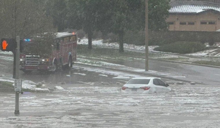
Floodwaters swept through low-lying intersections across the south Denver metro area Saturday afternoon, trapping drivers in vehicles that were lifted and pushed by rising water, hiding a treacherous secret underneath: feet of accumulated hail. Between 2:30 p.m. and 4 p.m., South Metro Fire Rescue responded to seven separate water rescue calls for vehicles stuck in flash flooding across Douglas County, as a burst of heavy monsoonal rain overwhelmed roadways in less than two hours.
At the intersection of Meridian Boulevard and Maroon Circle in Meridian, roughly two to three feet of hail had piled up beneath about three feet of standing floodwater, according to CBS News. That combination masked the true depth of the water from drivers who had no way of knowing what lay beneath the surface until it was too late. Multiple vehicles became immobilized as the water rose rapidly at the intersection, leaving motorists stranded in place.
Motorist Kevin Plamondon told the outlet he escaped through his car window after the floodwaters lifted his vehicle off the ground and swept it away near Meridian Boulevard and Maroon Circle. His account offers a firsthand look at just how fast conditions turned dangerous in a part of Douglas County better known for office parks than swift-water rescues. South Metro Fire Rescue and the Douglas County Sheriff's Office both responded to stranded motorists at multiple flooded intersections that afternoon, per Denver7.
A Downpour That Outpaced the Ground's Ability to Absorb It
The intensity of the rain was staggering by any regional measure. Rain gauges in Aurora recorded more than two inches of rain in a single hour around 3:14 p.m., an amount equal to roughly 12% of the city's average annual precipitation, as reported by 9NEWS. Aurora typically receives around 15 to 17 inches of total precipitation across an entire year, making Saturday's hourly total an extreme outlier for the region.
Denver7 also reported that a parking lot at the Aurora Costco on South Havana Street flooded, and at least one vehicle was submerged. Businesses in Evergreen reported flooding as well, and torrential rainfall caused widespread flooding across parts of the southern metro Denver area, according to the same report. As of Saturday, the extent of the damage remained unknown, though the outlet noted the flooding caused no major injuries.
Saturated ground played a major role in turning the downpour into an immediate crisis. Meteorological alerts from the National Weather Service and SECO News highlighted that days of prior rain had already saturated Front Range soils, preventing normal water infiltration and escalating flash flood risk when the heavier rain arrived. With the ground unable to absorb any more moisture, the runoff had nowhere to go but into streets and intersections.
The Palmer Divide's Role in Concentrating the Storms
Douglas County's geography helps explain why it bore the brunt of the storm. The county sits directly along the Palmer Divide, an elevated ridge south of Denver where shifts in elevation frequently force intense summer storm cells to dump heavy hail and rain along the Interstate 25 corridor, according to regional analysis from Upstream Roofers. Crews in Douglas County used snowplows to clear hail and floodwater from roadways, Denver7 reported, an unusual sight for mid-August that underscores just how much hail had piled up during the storm.
The National Weather Service office in Boulder had issued a Flash Flood Warning specifically for southern Douglas County effective through 4:45 p.m. Saturday, citing rapid runoff potential from monsoonal moisture, per 9NEWS. Storms had the highest chances of forming near the Palmer Divide, and monsoon moisture continued to linger across the area into the evening, though Denver7 reported that conditions were drying out early Sunday morning, with scattered showers and thunderstorms expected to redevelop later in the day.
Air Travel Snarled for a Second Straight Day
The flooding disrupted travel well beyond the roads. Denver International Airport temporarily halted departures due to thunderstorms, and Denver7 reported disruptions that included more than 550 delays and 60 cancellations. FlightAware separately recorded 708 delays and 93 cancellations by 4:30 p.m., while the Federal Aviation Administration issued a ground delay program averaging 114 minutes per flight, according to 9NEWS.
It was the second consecutive day of major weather-related trouble at DEN. The FAA had already ordered a ground stop at the airport Friday afternoon, resulting in 967 delays and 72 cancellations as severe monsoon storms battered the Front Range, DeepArrival reported. Together, the back-to-back disruptions point to a multi-day severe weather outbreak that stretched across the metro area rather than a single isolated storm.
A Recurring Front Range Hazard
Flash flooding remains the most serious natural hazard along Colorado's Front Range, according to the Mile High Flood District, the region's urban drainage management agency established in 1969 following the catastrophic 1965 South Platte River flood, which caused an estimated $300 million in damage in Denver alone and reshaped regional flood planning. Saturday's storm was a reminder of that long-standing vulnerability, even as the specific hazard of hail hidden beneath floodwater added a new wrinkle to the usual warnings about driving into standing water.





