

























































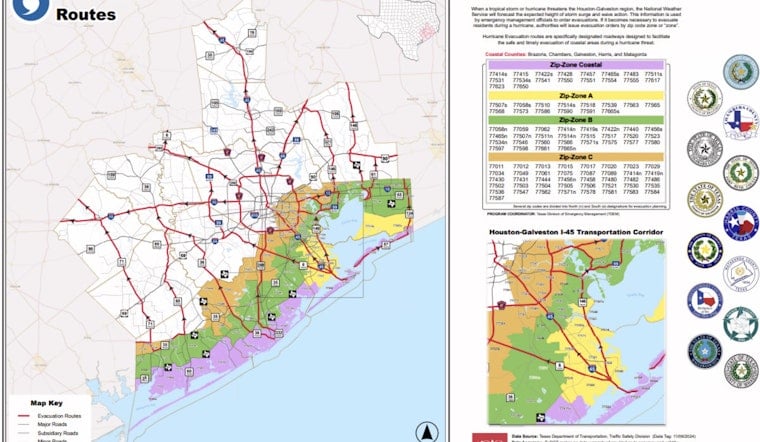
A zip-code-by-zip-code evacuation map is once again circulating across the Texas Gulf Coast, giving residents from Galveston to Chambers County a way to check exactly which zone they fall into before emergency managers ever call for an evacuation. The map, created by the Houston-Galveston Area Council, breaks the region down by risk level rather than treating the entire metro area as a single evacuation zone.
That zone-based approach exists because of what happened two decades ago. As reported by KHOU 11, roughly 3.7 million people fled Greater Houston during the 2005 Hurricane Rita evacuation, an exodus that produced massive highway gridlock and 107 evacuation-related deaths. Panic at the time led inland residents who faced no real storm surge threat to flee alongside coastal residents who genuinely needed to leave, clogging freeways and leaving people trapped in dangerous heat for hours.
How the Zip-Zone System Works
The current plan divides five coastal counties — Brazoria, Chambers, Galveston, Harris, and Matagorda — into four tiers: Zip-Zone Coastal, Zip-Zone A, Zip-Zone B, and Zip-Zone C, based on National Weather Service SLOSH storm surge modeling. The goal is to let residents facing the most immediate surge danger leave first while people farther inland shelter in place until it's their turn, rather than everyone hitting the highway at once.
Because storm surge risk can vary sharply even within a single zip code due to local elevation, several coastal zip codes on the map — including 77414, 77422, 77511, 77514, and 77546 — are split into separate North and South sub-zones. Residents in those areas need to check which half of their zip code they live in, since one side could face an active evacuation order while the other does not.
Highways Built to Flex Under Pressure
When evacuations are called, the Texas Department of Transportation relies on major outbound corridors including Interstate 45, Interstate 10, US Route 290, and US Route 59, where inbound lanes can be reversed into contraflow heading toward San Antonio, Austin, and Dallas. There's a notable exception, though: TxDOT guidelines explicitly prohibit using US 59 as a Houston-area evacuation route if the Beaumont area is evacuating at the same time, since a concurrent evacuation would bottleneck that corridor for both regions.
Short of a full contraflow reversal, TxDOT can also activate EvacuLanes — specially widened highway shoulders, with a recommended minimum width of 12 feet, that get temporarily converted into active travel lanes, such as along I-10 between Katy and San Antonio. Under Texas law, drivers in minor fender-bender crashes on designated evacuation routes are required to move their vehicles out of active travel lanes and onto the shoulder immediately, while disabled vehicles left on the shoulder get relocated to the next exit ramp. Minor collisions blocking travel lanes were a significant factor behind the 2005 gridlock.
Resources for Residents Who Need Help Getting Out
Texas also runs the free State of Texas Emergency Assistance Registry, known as STEAR, which lets people with disabilities, mobility limitations, or medical needs pre-register annually by calling 2-1-1 or signing up online to receive evacuation assistance from local emergency planners, according to the Office of the Governor of Texas. The program was created to close evacuation gaps for vulnerable residents that became apparent after the 2005 storms. During an active hurricane threat, TxDOT also posts live updates on open contraflow lanes, EvacuLane activations, and comfort stations offering water, oxygen, and ice through its travel portal, DriveTexas.org.
Emergency planners face a separate, growing challenge tied to how quickly Gulf storms can now intensify. Triggering complex highway contraflow requires 48 to 60 hours of advance notice ahead of landfall, plus up to 12 hours of operational setup time, according to research highlighted by the Houston Chronicle. Storms that strengthen rapidly near the coast can shrink that decision-making window dramatically, sometimes forcing officials to narrow evacuation orders even further than they otherwise would.
For now, officials are urging coastal residents to take the same three steps regardless of what any particular storm does this season: identify your specific zip code zone ahead of time, register with STEAR if you'll need medical or transportation assistance, and monitor DriveTexas.org for live lane reversals rather than relying only on a static map. Hoodline has previously reported on Houston-area flood insurance guidance and localized mandatory evacuation orders along the San Jacinto River, and on how this year's hurricane forecast dipped without erasing the need for preparation.





