

























































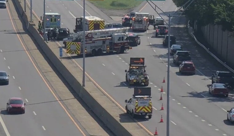
Seven people were hospitalized Thursday after a three-car crash shut down the ramp from Interstate 71 South to Interstate 480 West near Cleveland Hopkins International Airport, backing up traffic for roughly six miles. The Cleveland Division of Fire confirmed the injuries, though the exact conditions of those hurt were not known at the time of publication.
The crash occurred on the ramp connecting I-71 South to I-480 West, according to WKYC, which first reported the incident as it was still developing Thursday afternoon. EMS crews transported the injured from the scene, per officials cited in that report, and the ramp reopened after crews cleared the wreckage.
The stretch where the crash happened sits within one of Cuyahoga County's most tangled highway junctions. Traffic operations documentation from ODOT District 12 describes the I-71 and I-480 interchange near the airport as containing complex weaving lanes, rapid lane drops, and merge points connecting I-71, I-480, and State Route 237 within a two-mile span — a layout that handles heavy commuter and rental-car traffic every day.
A Corridor With a History of Trouble
Thursday's crash wasn't the first serious incident at this exact interchange. In December 2024, a multi-vehicle crash involving a semi-truck shut down the same I-71 South ramp at the I-480 and State Route 237 interchange for several hours, with winter weather contributing to a multi-mile backup at the time.
The interchange has also seen deliberate state intervention. Just weeks before Thursday's crash, on July 31, the Ohio Department of Transportation and the Ohio State Highway Patrol relocated Cuyahoga County's designated Speed and Seat Belt Safety Corridor to a 14-mile stretch along I-480, aiming to increase patrols and curb dangerous driving on the artery that intersects I-71. In 2023, ODOT District 12 had already added a third travel lane on I-480 West between I-71 and State Route 237 specifically to ease the daily commuter slowdowns that had affected airport access.
Recent Fatal Crashes Highlight the Risk Along I-71
The crash comes just days after a far more tragic incident along the same highway corridor. On August 15, a single-car crash on I-71 South in neighboring Middleburg Heights and Strongsville killed two Cleveland teenagers, 20-year-old Heaven Hennings and 19-year-old Caiden Ozanich, closing all southbound lanes between Pearl Road and Royalton Road for several hours, as Hoodline reported at the time.
Countywide data shows just how crash-prone these highways have become. Interstate 480 and Interstate 71 ranked as the second and third most crash-prone interstates in Cuyahoga County between 2023 and 2025, recording 2,901 and 1,689 crashes respectively, according to Ohio Department of Transportation crash data — trailing only Interstate 90, which recorded 3,872 collisions over the same three-year period.
Cuyahoga County recorded 24,205 total traffic crashes in 2025, an 8.2 percent increase from 22,370 the year before, even as traffic fatalities dropped 27.9 percent, falling from 118 deaths in 2024 to 85 in 2025, per the same state figures. Hit-and-run collisions also climbed, rising 7.8 percent from 4,174 in 2024 to 4,499 in 2025 and now accounting for roughly 18.6 percent of all crashes in the county. Under Ohio Revised Code Section 4549.02, drivers involved in a crash causing injury or property damage are legally required to stop and exchange information with other parties or police, with leaving the scene generally classified as a first-degree misdemeanor carrying up to 180 days in jail and license suspension.
Long-Term Planning Eyes the Same Stretch
Looking ahead, the Northeast Ohio Areawide Coordinating Agency has been studying traffic flow along the I-71 and I-480 corridors near Snow Road to prepare for potential congestion tied to a proposed Cleveland Browns domed stadium and development project in Brook Park. That 175-acre site sits about half a mile east of the airport, meaning the same interchange now under scrutiny for Thursday's crash could face even heavier demands in the years ahead.
No further details on the cause of Thursday's crash or the specific conditions of the seven hospitalized victims had been released as of publication. It remains unclear whether investigators will point to speed, lane weaving, or another factor tied to the interchange's notoriously tight geometry.





