

























































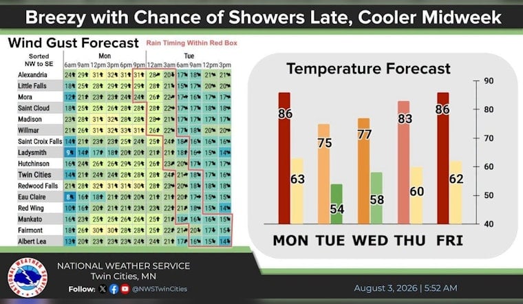
Minneapolis is starting Monday, August 3, with clear skies and temperatures around 70°F at Minneapolis-Saint Paul International Airport, but the breeze is already making itself known. Sunshine will push temperatures to near 87°F, setting up a warm and breezy afternoon across the city.
Warm, Windy Afternoon Ahead
South winds will run around 5 to 15 mph during the day, with stronger gusts possible across the region. Rain chances remain near zero through the afternoon, making Monday the week’s best early bet for outdoor plans before the weather turns more unsettled.
Storms Could Arrive After Midnight
The bigger shift comes late Monday night into early Tuesday, when showers and thunderstorms become possible after about 1 a.m. and continue into the morning. The National Weather Service Twin Cities says a few stronger storms could bring isolated damaging wind or hail, with the greatest concern in western Minnesota as storms weaken farther east.
Tuesday Brings Cooler Air And Possible Smoke
Tuesday should feel noticeably cooler, with a high near 78°F and mostly sunny skies after a slight chance of early showers or thunderstorms. The forecast also mentions patchy smoke between roughly 9 and 10 a.m., though confidence remains low on how much it will affect air quality.
Heat Rebounds By The End Of The Week
Temperatures ease into the low 80s Wednesday before climbing back to about 85°F Thursday and 88°F Friday and Saturday. Sunday stays warm near 86°F, but carries a 40% chance of showers and thunderstorms, so the weekend forecast may need another look before outdoor plans are locked in.
No active watches or warnings are listed for the area in the supplied forecast. If thunder rolls in during overnight or early-morning storms, head indoors and give the roads extra attention during any sudden downpour.




