

























































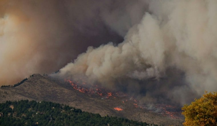
A wildfire burning in a remote stretch of Yosemite National Park has grown to 1,977 acres and is now 10% contained, fire officials reported Friday, as crews continue battling steep, rugged terrain north of Wawona Dome in Mariposa County. The Dome Fire was first reported around 8:28 a.m. Tuesday and is burning within a quarter-mile of Chilnualna Falls, one of southern Yosemite's most popular year-round waterfall hikes.
The fire's explosive early growth set the tone for the week: according to Outdoor Sportswire, the blaze expanded by more than 900 percent in a single day, jumping from about 100 acres to 1,100 acres by the morning of September 16 as south and southeast ridge winds drove flames through cured grass, brush, and timber. As reported by the Charlotte Observer, the fire remains active on its west and north flanks and has produced spot fires to the north, with gusty winds continuing to push flames through available fuels.
The cause of the Dome Fire remains under investigation, and officials say they continue to investigate how it started even as suppression efforts ramp up. Firefighters have built both direct and indirect hand lines around the perimeter while facing limited access through the wilderness terrain, per the Charlotte Observer's account of the incident.
Interagency Team Doubles Firefighting Force Overnight
California Interagency Incident Management Team 3 mobilized to Yosemite and assumed command of the Dome Fire on Thursday, and the number of personnel on the ground doubled from 187 to 376, according to myMotherLode.com. Three additional hotshot crews were assigned to the fire Thursday, and aircraft continue supporting suppression operations, the Charlotte Observer reports. The scaling response reflects the complex logistics of fighting fire in Yosemite's backcountry, where specialized air operations and elite ground crews are needed to reach the steep, granite-studded landscape.
Crews have leaned on the landscape itself for help. Firefighting teams have used natural granite features and portions of the 2017 Empire Fire's footprint to slow the Dome Fire's progression and anchor their suppression lines, the Charlotte Observer notes. That 2017 blaze burned more than 8,000 acres over 161 days and was largely managed by Yosemite officials for ecological benefit, according to ArcaMax, leaving behind a burn scar that now functions as a natural firebreak.
No Evacuations, But Trails and a Historic Hotel Closed
No evacuation orders or warnings have been issued, and the fire has not threatened any immediate infrastructure or developed areas, per the Charlotte Observer. Wawona — which includes lodging, cabins, and the Yosemite History Center — sits within a few miles of the fire, and no roadway closures have been announced. Wawona Road remains open, as do the major routes into Yosemite Valley.
Still, the fire's proximity to Wawona carries extra weight given the condition of one of the park's most storied buildings. The Victorian-era Wawona Hotel, established in 1856 and considered the oldest lodging facility in a U.S. national park, has been closed indefinitely since December 2024 after roof repairs uncovered severe structural deterioration, according to SFGATE. The outlet notes that tensions remain around potential smoke impacts on tourism and road access along Wawona Road even as the historic structure sits closed for unrelated reasons.
Recreation Closures Push Hikers to Eastern Access Points
The current closure order, in effect through September 30, blocks the Chilnualna Falls Trail — a strenuous 8.4-mile round-trip hike that climbs 2,300 feet — along with connecting wilderness routes to Buena Vista and Crescent lakes, according to the National Park Service. The closure area extends east of Wawona Road between Wawona and Chinquapin. Both Crescent Lake and Buena Vista Lake remain accessible from the east, the agency notes, giving hikers an alternate route around the fire zone.
Incident meteorologists expect elevation changes near Chilnualna Creek to moderate fire behavior even as regional forecasts call for gusts of 15 to 25 mph, the Park Service says. Yosemite's steep Sierra topography can produce localized wind shifts and temperature inversions that either suppress or redirect moving flames, adding an unpredictable variable to crews' containment efforts.
Smoke Lingers as Air Quality Swings
Smoke has been visible in parts of Yosemite and along Wawona Road, and officials have warned visitors to expect changing conditions as the fire continues to burn. Air quality in southern Yosemite has fluctuated between good and unhealthy levels, and fire officials are directing visitors to monitor real-time smoke outlooks through the interagency site fire.airnow.gov. The park itself remains open and operating normally, with officials emphasizing that smoke may affect visitors throughout portions of the park even without direct threats to developed areas.
The jurisdictional map around the fire involves more than one agency. CAL FIRE's Madera-Mariposa-Merced Unit is involved in the response, as CAL FIRE has supplied aerial resources to support the federal suppression effort while keeping watch for potential spread toward private land.
Echoes of the 2022 Washburn Fire
The Dome Fire is the latest wildfire to threaten the Yosemite area, following the 2022 Washburn Fire that burned near the Mariposa Grove of giant sequoias — a blaze firefighters responded to that summer. That fire scorched 4,886 acres and required more than 1,700 personnel, while firefighters worked to prevent damage to the ancient sequoias, according to SFGATE. The fire also prompted efforts to protect the sequoias during that 2022 fight.
Containment, fire officials note, refers to the portion of a fire's perimeter surrounded by secured control lines — meaning the current 10% figure reflects roughly a tenth of the Dome Fire's edge being held, not that the blaze is extinguished. Yosemite declared the start of its 2026 fire season back in early June, citing warm, breezy conditions that dried out vegetation across both low-elevation valleys and high country, as Hoodline reported at the time. Officials say weather conditions will continue to dictate whether fire lines hold through the rest of September, with updates available through Yosemite National Park, CAL FIRE, and InciWeb incident reports.


