

























































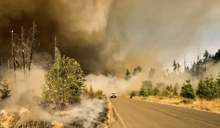
A new wildfire was discovered along West Hacienda Drive in the Higgins Area Fire Protection District outside Grass Valley on Tuesday, burning on private land in an area of southern Nevada County that has already seen fatal and fast-moving fires this summer. The blaze was first reported at 1:20 p.m., and as of the latest update, containment status had not been determined.
Fire Reported in High-Risk Wildland-Urban Interface
According to the Sacramento Bee, the wildfire was reported to the National Interagency Fire Center and remains classified as a new incident, with no cause yet determined and no containment figures available. The Bee's report, generated with AI based on newsroom templates reviewed and edited by journalists, was published Tuesday afternoon and updated shortly after. West Hacienda Drive sits within the jurisdiction of the Higgins Area Fire Protection District, a 90-square-mile rural service area covering roughly 12,000 residents from three fire stations, according to the Higgins Fire Protection District.
All emergency dispatches for the district are routed through CAL FIRE's Grass Valley Emergency Command Center, part of the Nevada-Yuba-Placer Unit, which oversees wildfire protection across 1.2 million acres in five foothill counties, per the fire district and CAL FIRE. West Hacienda Drive connects directly to Combie Road, a primary transportation and evacuation corridor for southern Nevada County and the nearby Lake of the Pines community, according to Nevada County. It is not yet known whether any evacuation warnings were issued for residents near Combie Road or Lake of the Pines in connection with Tuesday's fire.
A Summer Marked by Repeated Fire Activity
Tuesday's report follows a string of wildfires in the same corner of the county over the past several weeks. On August 9, a house and vegetation fire on Rodeo Flat Road in the Higgins Fire District outside Lake of the Pines killed two civilians and burned a tenth of an acre of surrounding brush before firefighters extinguished it, Hoodline previously reported on the fatal blaze. Weeks earlier, on July 28, CAL FIRE NEU and local agencies battled the 16.8-acre Combie Fire near Highway 49 and Sharonjack Road, which triggered mandatory evacuation orders before forward progress was stopped.
Nevada County has also seen fire activity elsewhere this summer, including a fast-moving vegetation fire that prompted evacuations near Nevada City and a blaze that torched 12 acres near Grass Valley amid 108-degree heat. The recurrence of fire activity in and around the Combie Road corridor underscores how exposed this stretch of southern Nevada County has become as the season wears on.
Elevated Fire Danger Baked Into the Landscape
The underlying risk in this part of the county is not new. CAL FIRE's State Responsibility Area hazard mapping shows that 303,863 of the county's 382,036 total SRA acres — nearly 80% — are classified as Very High Fire Hazard Severity Zones, according to YubaNet. Those classifications account for slope, vegetation fuel loading, and regional fire weather over a 30- to 50-year probability window. North Ops Predictive Services has projected above-normal significant fire potential across Northern California foothill regions through this month, citing dense grass fuel loads and warm summer drying trends, per the same outlet.September historically averages eight large wildland fire ignitions across Northern California following peak activity in July and August, YubaNet reports.
Property owners in high wildland fire severity zones, including the area where Tuesday's fire ignited, are required under Section L-II 4.3.18 of the Nevada County Land Use Code and California Public Resources Code Section 4291 to maintain 100 feet of defensible space clearance around occupied structures, according to Nevada County. County rules also require secondary road access and approved Fire Protection Plans for new development in these high-risk zones.
Local Response Capacity Has Been Expanding
The Higgins Fire Protection District has been working to shore up its response infrastructure in recent years. In January 2025, the district reopened Station 22 in the Dog Bar area after a decade-long closure, funded by a voter-approved $178.78 annual parcel assessment intended to speed up emergency response in rural neighborhoods, according to Firehouse Magazine. That station serves rural residential areas where fire and medical arrivals had previously taken up to 25 minutes.
Local fire agencies across the county, including Higgins, also inter-operate through joint agreements and Cal OES funding to preposition multi-agency engine task forces during periods of severe weather and elevated fire danger, YubaNet notes. Participating agencies include Nevada County Consolidated, Peardale Chicago Park, Grass Valley, Ophir Hill, North San Juan, and Higgins fire districts. As of the latest information available, the cause of Tuesday's fire on West Hacienda Drive had not been determined, and the exact acreage burned and containment percentage remained unclear.




