

























































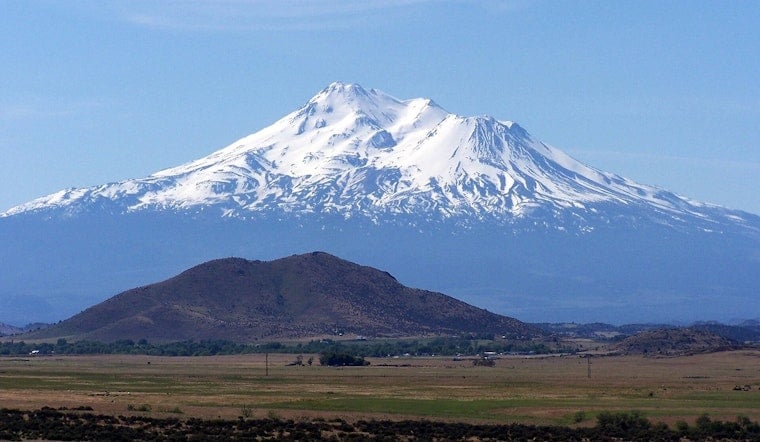
Three novice hikers from Roseville set out for the summit of Mount Shasta at 3 a.m. Sunday and did not make it back down as planned, instead spending a harrowing stretch stranded in the steep drainage of Mud Creek Canyon before search and rescue teams reached them Monday. What was supposed to be an eight-hour round trip turned into a multi-day ordeal after the group wandered off-route into the canyon on the mountain's southern side, according to authorities.
The hikers had relied heavily on Google's Gemini AI to plan their route and pack their gear, and the chatbot advised them to bring far less food and water than the group actually needed, according to a statement from the CBS Sacramento report on the sheriff's account. The group made base camp at about 8,400 feet the night before their summit push, then reached the top around 7 p.m. Sunday — hours past the 12 p.m. turnaround time that the Mount Shasta Avalanche Center and U.S. Forest Service advise all climbers to observe, since late-afternoon summits leave little daylight for a safe descent.
Descending in the dark, the hikers strayed off the trail into the Mud Creek Canyon drainage, a rugged stretch adjacent to the Clear Creek Route where off-trail wandering can force climbers into steep scree, cliff edges, and glaciated terrain, according to the Mount Shasta Avalanche Center. One of the three hikers fell and injured his knee during the ordeal. Unable to find their way back, the group called sheriff's dispatchers for directions and ultimately bivouacked overnight in the canyon.
Rescue Teams Reach the Group Monday Morning
The Siskiyou County Sheriff's Office deployed a search and rescue team, and a U.S. Forest Service Climbing Rangers team met the hikers Monday morning, per the sheriff's office's account relayed in the CBS Sacramento report. The hikers and rescue teams then returned to the trailhead without further incident. The sheriff's office reported that the rescue took place on Monday, capping an episode that began with the trio's 3 a.m. Sunday departure.
Officials noted this was the sixth call for service on Mount Shasta's Clear Creek Route within a two-week span, according to the Siskiyou County Sheriff's Office, underscoring that even a route often assumed to be low-risk because it avoids technical glacier climbing can still trap unprepared climbers. The sheriff's office advised hikers never to rely solely on AI for trip planning, and to avoid depending on just a smartphone or smartwatch for navigation. Officials also recommended calling the local USFS Mount Shasta Ranger Station before setting out, carrying multiple methods of wayfinding, stopping often to verify the correct route, and sticking to the 12 noon turnaround rule — since that timing gives both hikers and rescuers sufficient daylight to hike out safely.
A 14,179-Foot Volcano That Punishes Poor Planning
Mount Shasta is an active stratovolcano in the Shasta-Trinity National Forest that reaches 14,179 feet, making it California's fifth-highest peak, and standard routes require climbers to gain more than 7,000 vertical feet from the trailhead, according to the USDA Forest Service. The Clear Creek Route itself climbs roughly 7,000 vertical feet over six miles along a ridgeline that runs directly beside Mud Creek Canyon, where the terrain turns to steep scree and loose volcanic ash the moment hikers stray from the trail. The mountain carries seven glaciers and last erupted around 1786, with summit temperatures regularly dropping below freezing and afternoon storms creating hazards year-round regardless of which route climbers choose.
This was not the first major incident on the mountain this year. U.S. Forest Service Climbing Rangers and local search teams had already responded to multiple significant Mount Shasta rescues in 2026, including a March 8 operation to pull a climber to safety after a 700-foot slide down Avalanche Gulch.
AI Trip Planning Draws Wider Scrutiny
The Roseville group's ordeal echoes a pattern search and rescue organizations have flagged elsewhere. In May 2025, Lions Bay Search and Rescue in British Columbia issued public warnings after rescuing stranded hikers on Unnecessary Mountain who had relied on ChatGPT and Google Maps, noting that AI tools frequently fail to account for snowpack, terrain difficulty, and shifting weather, as Futurism reported. A March 2026 survey from Global Rescue found that 36% of travelers now expect AI to play a role in trip planning, even as safety organizations continue to warn that automated models cannot substitute for human judgment and verified local advisories.
Commercial outdoor apps have leaned into the same technology. AllTrails introduced AI-powered custom route generation in its paid Peak subscription in June 2025, a move that drew warnings from groups like BC AdventureSmart about hikers blindly trusting AI-generated itineraries instead of consulting official land managers, according to InsideHook. National Park Service backcountry guidelines still emphasize carrying physical topographic maps, compasses, or dedicated GPS units as part of what the agency calls the ten essentials, cautioning that mobile navigation apps routinely fail in remote areas due to dead batteries or missing trail data.
It remains an open question whether tech companies such as Google will add outdoor safety disclaimers to AI-generated travel queries, or whether the Forest Service or Siskiyou County officials will issue updated formal guidance on AI trip planning for high-altitude climbs. Mount Shasta has been the site of other emergency responses this year in Siskiyou County, including a standoff near Gumboot Lake that ended peacefully in July.





