

























































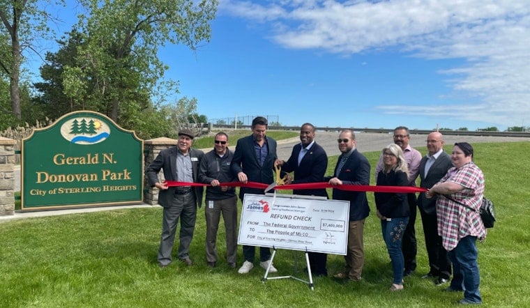
Construction crews are set to break ground this fall on a $10 million overhaul of Clinton River Road in Sterling Heights, a 4.5-mile stretch that carries thousands of drivers past two high schools, four parks and more than 3,100 households. The project will rebuild the roadway between Canal Road and Hayes Road in two phases over two construction seasons, with work pausing for winter before resuming in spring 2027 and wrapping by November 2027.
According to WXYZ Channel 7, the initial work this fall will focus on the sections between Canal Road and 19 Mile Road, and between Saal Road and Hayes Road. The station reports the project bundles underground utility replacement — water main, sanitary sewer and drainage work — with new asphalt pavement, modernized traffic signals, updated signage, and traffic-calming and intersection improvements designed to smooth out flow and improve safety for drivers, cyclists and pedestrians alike.
The funding breakdown adds real financial weight to the plan: $7.5 million comes from Congressionally Designated Spending secured by U.S. Rep. John James, while the remaining $2.5 million is state road funding provided under Public Act 51, according to the City of Sterling Heights. That means federal appropriations cover three-quarters of the total cost of rebuilding a corridor the city calls one of its key neighborhood arteries.
A Corridor Under Heavy Daily Use
Clinton River Road isn't just a residential cut-through. It's a two-lane collector carrying roughly 10,000 vehicles a day and connecting drivers to more than 500 commercial and industrial businesses within a two-mile radius, per Metromode. The road links directly to major arteries across Macomb County, according to the same WXYZ report, making it a lifeline for both neighborhood traffic and regional commuters passing through.
Sterling Heights Mayor Michael C. Taylor called the investment a major improvement for one of the city's key neighborhood corridors, per WXYZ's report. Access to homes and businesses will be maintained throughout construction, though the station notes drivers should expect changing traffic patterns, temporary lane restrictions, reduced speeds and detours once crews are on site.
New Signal Aims to Ease School Traffic
Among the most closely watched elements of the plan is a new traffic signal planned at Henry Ford II High School, addressing a stretch of road that already sees families, students and staff entering and exiting during pickup and drop-off. Robert S. Monroe, the former principal of Henry Ford II High School, said he appreciates the city's continued partnership to keep students and staff safe, according to WXYZ.
The new signal builds on work the Michigan Department of Transportation already completed nearby. In summer 2024, MDOT finished a separate $16 million M-53 corridor project that replaced the Clinton River Road bridge deck over M-53 and added a separated pedestrian walkway to the high school, according to C & G Newspapers. That earlier project closed a half-mile sidewalk gap between the school and 19 Mile Road, laying groundwork the current reconstruction now extends.
Trails, Trees and Traffic Calming
Beyond pavement and pipes, the project folds in green stormwater management systems and the planting of hundreds of new trees along the corridor, the city says — an urban forestry push tied to broader municipal efforts to restore tree canopy lost to invasive pests. New and upgraded sidewalks, pedestrian crossings and shared-use paths are also part of the plan, connecting residents to four major non-motorized trail networks, including Michigan's cross-state Iron Belle Trail, as well as local SMART bus routes.
The traffic-calming measures fit into a citywide safety push that predates this project. Sterling Heights City Council reviewed progress in March 2025 on a $500,000 federal Safe Streets for All grant that created a citywide Traffic Calming Task Force to implement Vision Zero strategies, studying high-crash corridors to design targeted fixes. Voters also backed the effort at the ballot box, approving the 0.9369-mill Pathway to Play and Preservation proposal in November 2024, which created dedicated funding for sidewalk completion, trail expansion and annual street tree plantings — and shifted sidewalk maintenance costs away from individual homeowner special assessments.
Part of a Bigger Infrastructure Push
The Clinton River Road work follows on the heels of the city's massive, multiyear Mound Road overhaul, a $217 million reconstruction of nine miles of roadway that reached substantial completion in 2024, with final wrap-up tasks extending into 2026. It also arrives just weeks after the city locked in plans to expand nearby Rotary Park into a 60-acre destination along the Clinton River, after the City Council approved a $600,000 property acquisition and $485,000 canoe launch purchase in August.
With an estimated population of about 133,851 residents spread across 36.7 square miles, Sterling Heights ranks as the second-largest suburb in Metro Detroit and the fourth-most populous city in Michigan, according to World Population Review. Taken together, the Clinton River Road project, the Mound Road rebuild and the Rotary Park expansion reflect a broader, sustained municipal investment in roads, trails and green space that residents have been funding and watching unfold for years.





