

























































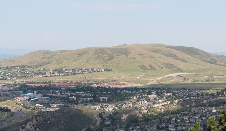
Lakewood officials have posted a draft plan for William F. Hayden Park that would add a long loop trail and mountain-bike zones around Green Mountain, the 2,400-acre park's centerpiece peak flanked by West Alameda Parkway, Colorado 470 and surrounding neighborhoods. Conservation is the plan's stated top goal, and its recommendations are intended to guide management over the next 10 to 20 years—not commit the city to building every proposed feature. The plan, shaped by 18 months of community input, could reach the Lakewood City Council for review as soon as December, according to Amber Thill, operations manager for Lakewood's Community Resources Department.
A Long-Awaited Blueprint Takes Shape
The city marked the planning project as a 95% plan on Oct. 5, according to lakewoodtogether.org, making the draft available for public review ahead of possible adoption later this year. Thill told the Denver Gazette the effort began about 18 months before publication. The city says thousands of community members, park users, stakeholders and partners took part. The document is meant to guide decisions for the next 10 to 20 years; projects will depend on funding, priorities, resource conditions and further design work.
William F. Hayden Park is already a heavily used slice of open space, drawing mountain bikers, dog walkers and hikers to a network the city currently lists at 36 miles of trails across 2,450 acres. Green Mountain's trails see 337,000 annual visits, per the Gazette's reporting, and the park offers singletrack accessible to a large swath of the Denver metro area. The existing shared-use network includes a 6,800-foot summit push up Green Mountain Trail, according to the city's planning site.
Base Loop and Bike Zones at the Center of the Plan
The plan's centerpiece is an 11-mile base loop that would circle Green Mountain by connecting existing trails with new routes. Planners envision it as a way to link trailheads and neighborhood streets, with access points and wayfinding signs, while also providing a route toward the mountain. Thill told the Gazette the loop would serve the mountain's north side, where many of the social trails identified for closure are located.
The draft also maps three prospective mountain-bike zones, but Lakewood staff say the areas need further design and on-the-ground review before any construction. The city plans to work with community partners on the trail layouts. The proposed network totals 41 miles, up from the current 36 miles of city-listed trails; the park also has about 14 miles of unofficial social trails.
Separating Riders and Hikers Has Precedent Elsewhere
The push to carve out dedicated biking terrain echoes efforts already underway across Colorado's foothills. Gary Moore, executive director of the Colorado Mountain Bike Association who lives near Morrison, told the Gazette that heavy mixed use on popular trails has produced close calls and crashes between uphill hikers and downhill riders, and he said he's seen similar conflicts play out broadly across Jefferson County Open Space, where, according to the Daily Camera, officials have run an alternating-day access system at Centennial Cone Park for more than a decade and added biker-only trails at Matthews/Winters and White Ranch parks. Moore noted that an average popular trail system draws around 100,000 visits a year — a fraction of Green Mountain's traffic — and said separated-use management tends to reduce conflict and make trails more comfortable for everyone.
Moore also cited single-use trail projects at Floyd Hill, Maryland Mountain and Virginia Canyon Mountain Park. The Colorado Mountain Bike Association says Floyd Hill's system reached 11 constructed miles, with the final mile completed in September 2020, after a 2018 master plan called for about 13 miles. The Sluice, a 1.3-mile bike-only directional downhill trail, was built for riders to descend without sharing the route with hikers, runners, dogs or uphill cyclists, the Colorado Sun reported when it opened. The Daily Camera reports that Black Hawk built a single-use park at Maryland Mountain, while Idaho Springs is developing a mountain park in Virginia Canyon with the mountain bike association, offering free access to bikers and hikers.
Jefferson County’s Pilot Rules and Reported Results
Jefferson County Open Space used a time-based approach at Apex Park: its management plan took effect Sept. 10, 2020, as a one-year trial, reserving certain trails for bikes on even dates and hikers and equestrians on odd dates, according to Jefferson County Open Space. That calendar-based system differs from Lakewood's proposed bike zones. At White Ranch Park, Middle Longhorn Trail became a permanent mountain-bike-only, one-way trail on June 19, 2019, after a one-year pilot. The county reports approximately 98% compliance and says more than 80% of surveyed people were satisfied or in favor of the designation.
Trail Advocates Split on Where Separation Fits
Views in Lakewood's planning process have differed on whether separate-use trails are the right answer. Brian Curtin, representing the Front Range Trails Conservancy, told the Gazette that bike-only routes could work at Hayden Park if there is enough room and the trails can be built sustainably, rather than shifting conflicts elsewhere. His group helped build a hiking-only bypass along the Rooney Valley Trail. Thill has said participants expressed both support for more biking infrastructure and opposition to changes.
Conservation is described as the plan's top overall goal, and the draft was shaped by a detailed ecological analysis that mapped wildlife corridors, fragile plants and wetlands across the park. That analysis helped identify roughly 9.6 miles of social trails recommended for closure, since unofficial paths have been linked to vegetation damage and the spread of invasive weeds. Separately, Lakewood is already rerouting a segment of Green Mountain Trail southeast of the Rooney Road Trailhead, where the existing route's fall-line design has caused widening, braiding, erosion and rutting; the new segment will be built four feet wide with a grade below 10% and erosion-control features, according to the city's trail improvement page.
Parking Pushback and What Comes Next
Not every proposal survived public comment. Lakewood residents raised concerns about traffic and parking near Alkire Street and Cedar Drive, and officials ultimately removed a proposed parking expansion at a trailhead in that area after the pushback. The city says the plan will rely on periodic monitoring to guide implementation going forward, with trailhead improvements, expansions, trail construction and the new bike zones broken into five development phases — phase timelines will hinge on available staff and funding, officials say.
Thill said completion within roughly 10 years could be feasible if the needed resources materialize, though the city continues to frame the document as a flexible guide rather than a fixed construction schedule. With the council review potentially landing in December, the draft's fate — and how much of its 41-mile vision ultimately gets built — now moves into public and political hands.





