

























































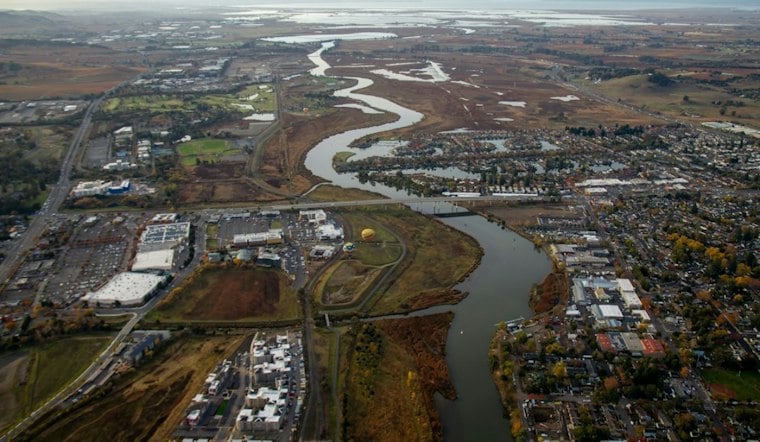
A new park at the end of South Jefferson Street in Napa is giving walkers a dirt trail along the Napa River while plans take shape to turn former vineyard land back into tidal wetlands. The Napa River Estuary Open Space Park is open to the public now, even as the larger restoration effort around it is still being planned and funded.
The park is on land in the Napa River estuary, near Highway 29, that the Napa County Flood Control and Water Conservation District purchased in 2024, according to The Press Democrat. The park is part of the broader Napa River Estuary Enhancement and Public Access Project, which aims to restore 46 acres historically used for vineyards into tidal wetlands. The San Francisco Bay Restoration Authority describes the broader goal simply as plans to “restore 46 acres of tidal wetlands” along the river’s west bank.
The trail itself starts about a half-mile south of where South Jefferson Street ends, functioning as an access dirt path leading to a levee. It loops through the area slated for wetlands restoration, giving visitors an early look at land planned for a future transition from farmland to marsh.
Grants Cover Planning, But Design Isn’t Fully Funded
Money has come in from several directions to get the project this far. Per engineering technician Joseph Panchesson of the flood control district, the California Department of Parks and Recreation provided $2.55 million in acquisition grants and the California Coastal Conservancy kicked in another $2.51 million. The San Francisco Bay Restoration Authority separately provided a $600,000 grant, and district staff are applying for additional matching grants of between $500,000 and $1 million, the station’s report notes.
Even with that funding stacking up, the project’s design phase is not fully funded, and per the article it likely will not be fully funded until 2027. Design work will begin only after funding is secured and a designer is selected, at which point three alternatives will be presented to the public for input, according to Panchesson.
Levee Breaches, Bridges and an Interpretive Barn
Panchesson, speaking at a district meeting, said the estuary project has more work planned beyond what’s visible today. The district plans to breach the trail levee and build bridges over those breaches, a move intended to reintroduce tidal influence from the Napa River and restore habitat. The same project page from the San Francisco Bay Restoration Authority describes converting an unused barn into an interpretive center and redeveloping an existing levee into a pedestrian trail, with the City of Napa and the Napa County Regional Park and Open Space District set to manage and maintain those public access areas and the center as free amenities.
Interpretive signs are also part of the plan. The district intends to add signage covering the wetlands’ ecological benefits, historical land use and local species, while separately considering whether to repurpose the property’s existing barn into that interpretive center. The restoration authority’s project materials add that two tribes culturally affiliated with the project area have expressed interest in consulting on its design and implementation.
Mayor Eyes a Bigger Connected Greenway
Napa Mayor Scott Sedgley, who chairs the flood district board, said the city is working to incorporate its own property with the current park. Napa owns 50 acres immediately south of South Jefferson Street that had previously been envisioned as a park site. Sedgley told the newspaper he envisions the area ultimately extending under Highway 29 and connecting to Stanley Lane to the south.
“That’s still down the road aways, and we’ll get this part done first,” Sedgley said, according to the same report. That ambition isn’t without local precedent: a 2010 city park master plan for the nearby South Jefferson site, per the Napa Valley Register, also called for a more natural park with trails and wildlife-viewing areas, though that plan went dormant for years before resurfacing.
A Larger Regional Pattern of Wetlands Work
Napa’s project isn’t the only local effort converting industrial or agricultural land back into tidal marsh. A separate restoration in south Napa County targeted about 1,000 acres of former Cargill Salt Co. industrial ponds, according to the Napa Valley Register. That effort drew an $8.5 million federal funding boost on top of $7.9 million in state Proposition 50 bond money set aside in 2008, and involved excavating historic channels and breaching levees to bring back tidal flows and, over time, marsh vegetation. Officials at the time said the entire restoration could be completed by late fall 2010.
For now, the Napa River Estuary Open Space Park offers a smaller-scale but tangible version of that same idea: a trail open to walkers today, built atop a landscape district officials hope will look very different in the years ahead as funding for the fuller design comes together.




