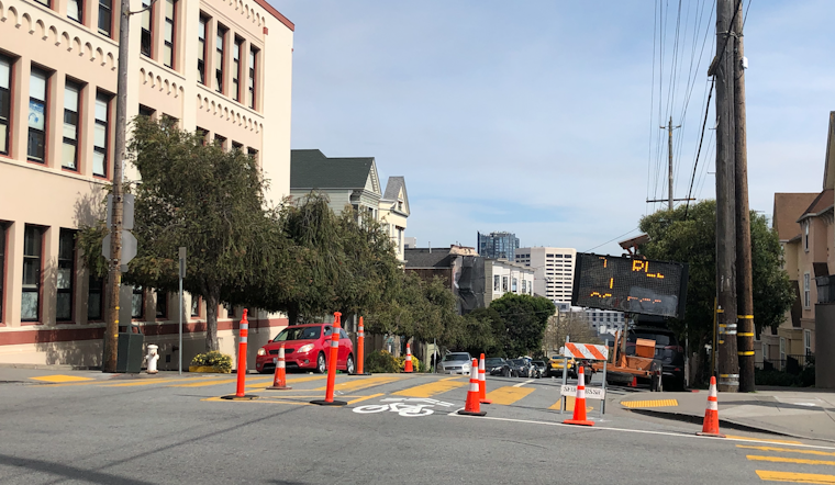
On Tuesday morning, the San Francisco Municipal Transportation Agency (SFMTA) announced that it plans to close select streets to vehicular traffic, in order to provide more space for pedestrians and cyclists to socially distance under the COVID-19 shelter-in-place order.
The move comes nearly two weeks after Oakland closed 74 miles of streets to traffic for similar reasons, an inspiration Mayor London Breed acknowledged on Twitter.
San Francisco's street closures will be far less extensive than Oakland's.
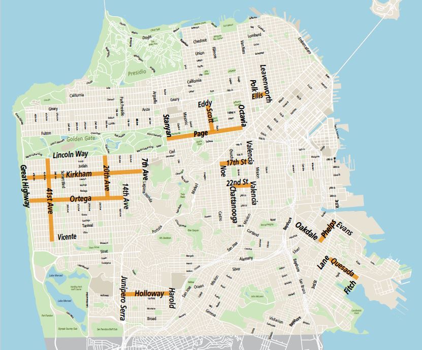
The proposed streets for the program include Ortega Street (between Great Highway and 14th Avenue), Kirkham Street (between Great Highway and 7th Avenue), 17th Street (between Noe and Valencia), 22nd Street (between Valencia and Chattanooga), Page Street (between Stanyan and Octavia), Scott Street (between Eddy and Page) and Ellis Street (between Polk and Leavenworth).
Large swaths of the city have been left out of the program, including all of District 3 (North Beach, Chinatown and the Financial District), District 1 (the Richmond) and most of District 6 (SoMa and the Tenderloin). The Marina District, Russian Hill, the Excelsior District and Potrero Hill/Dogpatch are other notable omissions.
On Twitter, District 3 Supervisor Aaron Peskin and District 6 Supervisor Matt Haney expressed frustration about the lack of additional car-free spaces in their districts, with Peskin adding that he wasn't consulted on the plan.
I have no idea how SFMTA came up with this bc apparently they didn't have time to reach out. At first glance, they seem more concerned w recreating in less dense areas than responding to requests to address social distancing needs of seniors & low income people of color in D3. https://t.co/17QBcDBzGI
— Aaron Peskin (@AaronPeskin) April 21, 2020
Good to finally see some commitments on opening up some streets
— Matt Haney (@MattHaneySF) April 21, 2020
But makes no sense to exclude SOMA entirely + only include couple blocks in the TL
These neighborhoods still have crowded sidewalks & more foot traffic. We have huge need for space—I’ve been clear I support more. https://t.co/xRuoZsxDpx
The plan also continues to allow vehicles on JFK Drive in Golden Gate Park, despite the protests of many pedestrian and bicycle advocates who say the current sidewalks don't allow for sufficient social distancing.
The SFMTA has emphasized that the initial "Slow Streets" are intended to replace streets where key Muni lines have been cut, allowing residents to walk or cycle safely instead. All are low-traffic residential streets that aren't heavily used by emergency services.
"With so much Muni service cut, SF's essential workers need safer bike corridors and last-mile connections to transit," SFMTA director Jeffrey Tumlin wrote on Twitter.
According to SFMTA, two to three of the "Slow Streets" corridors will be implemented weekly starting this week, with signage and traffic cones indicating the changes. A maximum of eight blocks will be closed at a time, and residents who need parking or driveway access to otherwise closed blocks will still have the right-of-way over pedestrians.
Pedestrian and cyclist advocates say they hope the program will expand further, and faster. Jodie Medeiros, executive director of Walk SF, said that the Tenderloin and Chinatown are the two San Francisco neighborhoods most in need of safe pedestrian space.
"We look forward to working with our members and city partners to quickly identify additional streets in our eastern neighborhoods and parks where crowding is most extreme," the SF Bicycle Coalition added on Twitter.




-1.webp?w=1000&h=1000&fit=crop&crop:edges)