The Bay Area is preparing to don its rain gear yet again as meteorologists forecast a soggy interruption to the dry days. According to a tweet from the NWS Bay Area, the region should brace to clutch their umbrellas as rain makes a grand entrance Tuesday evening, with plans to stick around through early Friday.
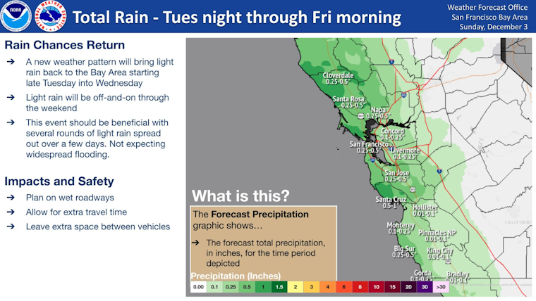
Rain returns to the region Tuesday night and persists at times through early Friday. Plan on wet roadways and slower commute times. Here's a look at how much rain we're expecting along with the probabilities for seeing some specific amounts. #cawx pic.twitter.com/1COce5a15r
— NWS Bay Area 🌉 (@NWSBayArea) December 3, 2023
City streets stretching from Cloverdale to San Jose are in for a thorough soaking as a wet spell is forecast to bring up to half an inch of rain. This downpour has the potential to significantly impact commuters' travel times, slowing down their usual pace.
The National Weather Service (NWS) issued a dense fog advisory for the North Bay, warning drivers about visibility dropping to a quarter-mile this morning. This thick fog, known as a pea-souper, quietly infiltrates the interior valleys and the northern part of San Francisco Bay.
As if that weren't enough, the National Weather Service has raised concerns about sneaky aquatic threats called sneaker waves. CBS San Francisco reported that these unpredictable waves might crash onto the coast starting Monday afternoon. Sneaker waves seemingly appear out of nowhere and can have the strength to drag unsuspecting beachgoers or even large logs out to sea.
With the Beach Hazards Statement extending its warning to beaches as far south as Big Sur, authorities are urging the public to exercise caution. It's advised to avoid rocky areas, jetties, and steep beaches, ensuring a safe distance from the unpredictable tides. The sea can transition from calm to disastrous in a short time.


