San Diego residents and visitors are facing a rollercoaster of weather conditions, from foggy mornings to potential coastal flooding caused by high surf, weather officials reported. An X post from the National Weather Service (NWS) San Diego warned drivers about foggy conditions impacting areas of the Inland Empire this Thursday morning. Visibility is expected to improve by mid-morning, but caution on the roads is advised.
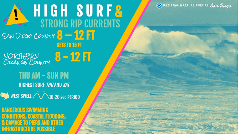
Meanwhile, the coast is bracing for another type of challenge. A High Surf Warning has been issued for San Diego County Coastal Areas, effective from 8 AM Thursday to 2 AM PST Monday. According to the NWS, "dangerously large breaking waves of 8 to 12 feet with sets to 15 feet" are expected, which could lead to life-threatening swimming conditions and significant beach erosion. Additionally, minor coastal flooding is on the cards for low-lying areas - potentially impacting locales like Cardiff and Seaside State beaches and portions of Del Mar, La Jolla Shores, Mission Beach, and Imperial Beach.
High surf is still expected at San Diego and Orange County beaches Thu through late Sun. Surf will peak Thu and Sat. High surf will generate strong, dangerous, rip currents & areas of coastal flooding. The highest surf has the potential to damage piers in San Diego Co. #CAwx pic.twitter.com/zkJwVJaDJI
— NWS San Diego (@NWSSanDiego) December 27, 2023
On the meteorological front, an NWS forecast predicts that the dry weather will persist through Friday, with high temperatures slightly above average. However, a twist in the tale comes with the approach of a low-pressure system from the west, which will cause temperatures to drop and bring showers and a possible thunderstorm on Saturday.
The situation in the mountains is set to get icy, as snow levels on Saturday are expected to be around 6500 feet, with "a few to around 5 inches of snowfall possible, mostly above 7000 feet," NWS San Diego indicated. As for the ocean, the mariners aren't out of troubled waters just yet. The marine forecast calls for two large, long-period west swells that might generate waves up to 13 feet high, especially hazardous for small crafts near the shore. Beachgoers should also tread cautiously, as strong rip currents are expected through early next week.
The outlook heading into the New Year doesn't offer much respite, with a detailed forecast suggesting more precipitation. There is a slight chance of showers for the first part of next week and additional opportunities for more rainfall around Wednesday and Thursday.


