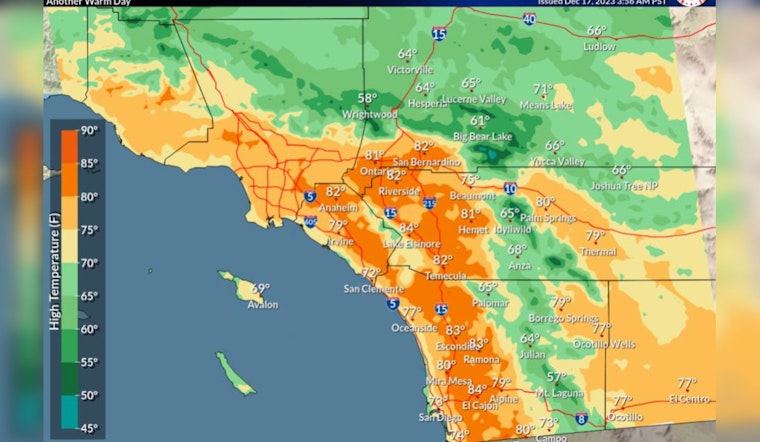
San Diegans can expect to bask in another day of warm weather before temperatures cool and rain chances increase throughout the week, forecasters said. According to the National Weather Service, today's highs will range from 70 to 75 near the coast and reach the mid-80s inland, whereas the mountain regions will experience highs in the 60s; meanwhile, both the low and high deserts are anticipated to have highs near 80 and in the 60s, respectively.
However, a change is on the horizon, with temperatures expected to dip slightly on Monday, especially west of the mountains, with coastal areas seeing highs in the upper 60s and valleys in the 70s, and as the week progresses, rain chances are set to peak on Tuesday, especially in coastal, valley, and mountain areas where chances range from 25 to 50 percent; this is compared to a lower side 10 to 20 percent chance in the lower deserts.
The weather discussion from the NWS pinpoints a strong ridge aloft combined with a weak offshore flow that will sustain the warmth today, though residents can expect the high clouds to thicken and lower into Monday and Tuesday, hinting at the possibility of light rain. This wetter trend is likely to culminate in more significant rainfall from mid- to late-week as a cold upper low sweeps across the area, increasing the risk of thunderstorms on Thursday and Friday.
Moreover, after remaining dry today with east to northeast winds reaching up to 35 mph through the passes and canyons coupled with humidity levels dropping to a parching 10–20%, an uptick in humidity is forecast for Monday, signaling a reprieve from the current fiery conditions that have locals on alert. This anticipated recovery coincides with the onset of onshore flow and an increment in atmospheric moisture.
As for the coastal regions, a detailed forecast by NWS mentions a west swell that could create surf heights of 3 to 5 feet, with possible sets up to 6 feet, potentially growing higher later this week due to an incoming Pacific storm. Rip currents are expected to be hazardous, and there's even a possibility of lightning strikes beginning Tuesday night through Thursday evening, adding a dramatic flair to an already dynamic weather week.


