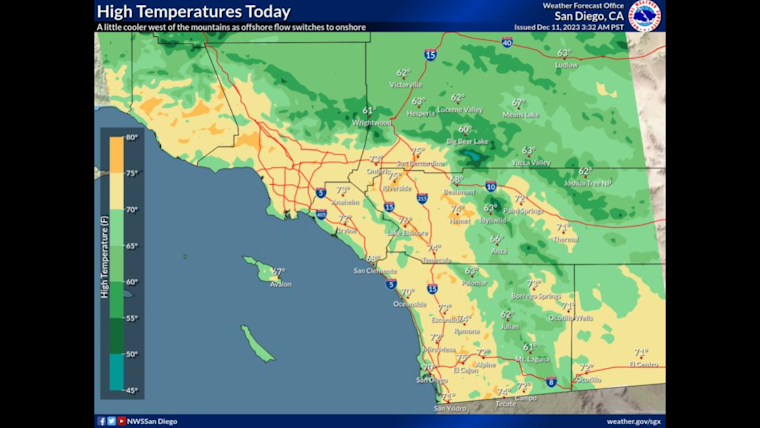
As the Southland navigates a brief cooldown, offshore breezes, and the possibility of fog, locals can expect varied weather patterns in the coming week. According to the National Weather Service San Diego, today's high temperatures will stay between the mid-60s and lower 70s in lower elevations, while the mountains will see 50s and the high desert, lower 60s. The forecast discussion from the National Weather Service indicates a transition day as high pressure gives way to a weak trough of low pressure, which should increase onshore flow and potentially redevelop a marine layer.
The ongoing weather shift means coastal areas might see low clouds and fog during the night and mornings of Tuesday into Wednesday, with a "small chance some true fog will develop Tuesday morning near the coast," as reported by the NWS Area Forecast Discussion. Following this brief period of coastal cloudiness and potential fog, offshore flow is anticipated to return with weak to moderate northeast winds hitting the foothills and some inland valleys mid-week. A more substantial marine layer, however, is expected to bring humid conditions and temperature relief west of the mountains.
Focusing on the finer details provided in the detailed 7-day forecast, the region is poised for mostly sunny skies, with high temperatures steadily climbing throughout the week, peaking in the mid-70s by the weekend. And while the nights may see some patchy fog, particularly after 4 a.m. tonight and before 10 a.m. Tuesday, clear conditions are expected predominantly, with low temperatures hovering around the low 50s.
For those concerned about fire weather, the NWS has highlighted that humidity will recover robustly today into Wednesday, minimizing fire risk as the region moves away from dry conditions, even though portions of the foothills and the northern Inland Empire should prepare for gusty conditions on Wednesday. "After a modest recovery in maximum humidity this morning, the minimums will again be in the 10-15% range today," the National Weather Service cautions, "but overall, winds will be light today, and trending back onshore." As for maritime conditions, no marine weather hazards are forecasted through Friday, maintaining clear sailing for seafarers throughout the week.
Forecasters looking ahead suggest that while the week's weather will be relatively tame, the long-term outlook hints at precipitation. "When will it rain? A very fuzzy picture says probably some time next week," NWS proclaims, with a range of projections either pointing to early next week or a potential for continued dryness. Nonetheless, for those seeking a calm, pleasant week weather-wise in Southern California, they'll find just that, with the added bonus of some picturesque high clouds gracing this week's sunrises and sunsets.


