As the winds change in San Diego, residents can expect to see a shift from the crisp chill of recent days to a toastier climate towards the end of the week. According to the National Weather Service’s San Diego office, Wednesday is set to see temperatures reach the mid-60s to lower 70s across the lower elevations, including the coast and valleys, courtesy of a strong ridge building aloft which is sure to bring a bit of warmth back to the sun-seekers of Southern California.
A developing low pressure in the Lower Colorado River Valley is driving better onshore flow, which is expected to spread marine air and cool. However, Santa Ana winds are predicted to kick in to quickly whisk away the low clouds by Wednesday, making for dry and warmer days ahead. Locals should watch out for gusty winds, particularly "along the coastal foothills and below passes," reported NWS San Diego. These winds are anticipated to remain persistently moderate, mostly during nights and mornings into the weekend.
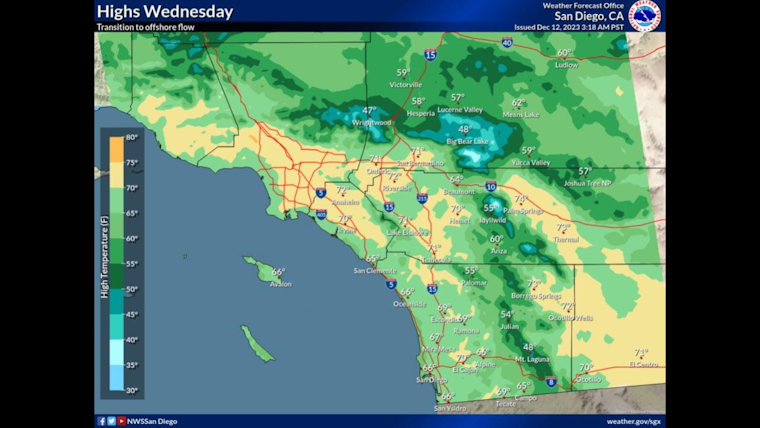
High temperatures Wednesday will the mid 60s to lower 70s across the lower elevations including the coast and valleys, 50s in the mountains, and lower 60s in the high desert. #cawx pic.twitter.com/mH4t3ukHAD
— NWS San Diego (@NWSSanDiego) December 12, 2023
For inland valley dwellers, Tuesday brought a chill, with areas like Valley Center and Ramona dipping below the freezing mark in the wee hours. These conditions contrasted sharply with the coastal regions, where a steadfast coastal eddy kept the humidity up and the frost at bay. "It will warm rapidly today, but not as warm as yesterday," the National Weather Service noted, signaling the beginning of a heating trend that's supposed to continue into the weekend with "lots of 70s and even lower 80s at lower elevations," per the Area Forecast Discussion.
Looking further into the week, the fire weather conditions bear monitoring. With the marine layer deepening, the air across the region will carry more moisture today, but the growing offshore winds paired with an increasingly warm and dry atmosphere by Friday might heighten the fire risk. "The combination of much above average high temperatures, low RH, and locally gusty winds could elevate fire weather conditions in these areas Friday into the weekend," the National Weather Service warned.
Despite the anticipated heat wave, change is again on the horizon next week, with the potential for rain. Forecasters are looking for a "giant trough of low pressure," which might just scoop up enough tropical moisture to dampen spirits and the ground by Monday. Although the amount and timing of this possible rain are uncertain, the NWS already hints at a slim chance of showers.
No marine hazards are expected up to Friday, and while Skywarn activation isn't called for, weather spotters are still encouraged to report any significant meteorological events. For now, San Diegans can prepare to enjoy a stretch of clear skies and warmer weather.


