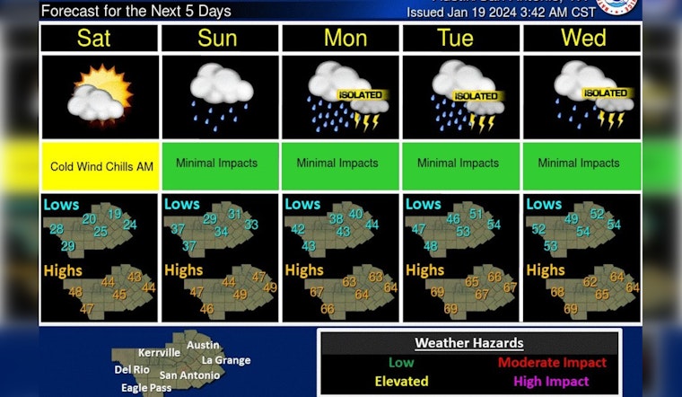
Austin residents braced for a significant temperature drop as an Arctic front made its way through Central Texas, leading to a sharp decrease in today’s high to a chilly 46 degrees. This cold blast was accompanied by a robust north wind with gusts reaching 35 mph. According to the National Weather Service (NWS), tonight's clear skies will not offer much respite, as the mercury is expected quickly to plummet to a low around 23 with wind chills potentially dipping into the teens.
Looking ahead, the weekend is set quickly to bring increasing clouds on Saturday and a high near 44 degrees. As per the NWS, a mix of clouds will roll in Saturday night, leading to a low of around 32 degrees. Sunday's forecast suggests a shift, with a 30 percent chance of showers after noon and a high again near 46, but showers are expected to intensify overnight.
Sunny, windy, and cooler again today behind this morning's cold front. A pattern change is still in store for the beginning of next week with multiple rounds of rainfall likely. Heavy rainfall remains possible along and east of I-35. #txwx pic.twitter.com/yQTw2XrO91
— NWS Austin/San Antonio (@NWSSanAntonio) January 19, 2024
According to KVUE, by Monday, the city should brace for showers and likely a thunderstorm with a high near 62 degrees. The continued precipitation brings concern for potential heavy rainfall Sunday night into Monday morning, especially along and east of Interstate 35. The NWS hazardous weather outlook issued a warning for potential "marginal to slight risks for heavy rainfall," urging residents to check back for updates as the week progresses.
Midweek, more moisture will be added to the fray with a warm front and continued rain chances. By next Thursday, Austin could see a slight decrease in showers, with only a 20 percent chance of precipitation and partly sunny conditions. KVUE's forecast showed "anywhere from two to four inches of rain over the next several days," which could pose a flooding threat for the region.


