Austin is bracing for a barrage of weather-related challenges today. Residents can expect to see everything from rain showers to a severe storm risk and powerful winds, according to forecasts. In addition to the precipitation, there’s a significant temperature drop on the horizon within the next 24 hours, which is sure to have locals bundling up.
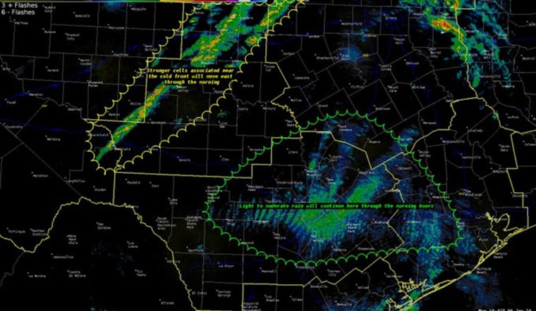
450AM: Have an umbrella for the morning commute. Light to moderate rain will continue near the I35 corridor and Coastal Plains. Activity associated with the cold front is to our northwest but tracking east. pic.twitter.com/NRi37U74y4
— NWS Austin/San Antonio (@NWSSanAntonio) January 8, 2024
The day may start with drizzle, but conditions are expected to worsen by noon. The potential for severe weather events, including damaging winds, brief tornadoes, and hail is particularly high east of the I-35 corridor. Moreover, most areas will see less than a quarter inch of rain, but some spots could face heftier downpours, as reported by KXAN,
A breezy conditions with a south wind reaching 15 to 20 mph, shifting west in the afternoon with possible gusts as high as 30 mph. Tonight will offer little respite for Austinites, as the skies clear up but the strong winds persist, gusting up to 40 mph, as per the National Weather Service.
Commuters should take caution as the weather advisory remains effective through noon Tuesday. Officials advise securing outdoor objects and being mindful of the possibility of, tree limbs falling, and resulting in power outages. "Use extra caution when driving, especially if operating a high-profile vehicle," the advisory emphasizes, according to the National Weather Service, Wind Advisory
Looking ahead, Tuesday promises sunny skies but continued brisk conditions with northwest winds gusting as high as 35 mph. The rest of the week fluctuates in temperature and conditions but another round of rain and strong winds is set to close out the week on Friday, shuffling the deck yet again for Texans trying to navigate the tumultuous weather.


