Today's forecast has predicted a day of patchy fog followed by gradual clearing in Austin, with the high expected to hover near 66 degrees; skies will clear up completely tonight, dipping to a low around 39, as per The National Weather Service.
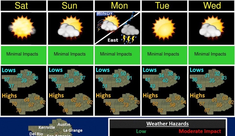
Scattered showers and isolated thunderstorms are possible this morning ahead of the Pacific frontal passage. Skies begin to clear from west to east throughout the day. A stronger cold front is expected on Monday with a lot of winds and the potential for severe storms east. #txwx pic.twitter.com/fg5NZfR8M7
— NWS Austin/San Antonio (@NWSSanAntonio) January 5, 2024
This comes after "Areas of dense fog reducing visibility to 1/4 mile or less" hit parts of South-Central Texas this morning, and as conditions are set to remain sunny through the weekend, notwithstanding the mild afternoons, gusty winds and low humidity this afternoon might pose a fire weather threat particularly over the southern Edwards Plateau and the Rio Grande, according to the Hazardous Weather Outlook.
After rains cleared out this morning, the weather for this weekend should stay predominantly sunny with normal temperatures for this time of the year, although Monday may see some variabilities as another storm system is expected to move in late Sunday into Monday, "bringing a chance of rain and thunderstorms Monday afternoon followed by colder temperatures and feisty winds," the weekend should offer Austinites a welcome respite from the unsettled weather pattern we've been experiencing, reported by KXAN.
Weather forecasts for the early part of next week appear equally tumultuous with "Monday A 50 percent chance of showers and thunderstorms, mainly before noon" followed by a partly sunny afternoon with a high around 73, and heavy gusts of Northwest wind between 20 to 30 mph, potentially raising again with elevated to critical fire weather conditions that could see wind advisories in effect, Tuesday will calm down with sunny skies and less aggressive winds, as stated by The National Weather Service.


