The city of Austin readies itself for a bout of inclement weather today and into the early hours of Monday, with forecasters at the National Weather Service predicting mostly cloudy skies and a high near 73 degrees, but the tranquility is not expected to last—gusty showers and thunderstorms are expected to barrel into the region after dark. According to the National Weather Service, the South wind could whip up to 20 mph, with potential gusts as high as 30 mph, while tonight's low is pegged around 59 degrees, and the chance of precipitation could skyrocket to 70%, bringing rainfall that could be heavier in thunderous outbursts.
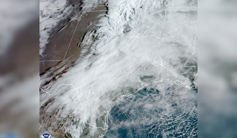
STORM ALERT: Late-night thunderclaps and downpours are set to rattle Central Texas with KXAN detailing an upper-level trough sweeping from the southwest U.S. eastward, which is gunning a Pacific cold front toward Austin and could stir up a line of thunderstorms in the neighboring counties of San Saba and Mason between 10 p.m. and midnight, these tempestuous conditions are slated to intensify over Hill Country then weaken as they straddle and cross over I-35 between 4 and 6 a.m. KXAN reports future radar indicating a weakening of the storms as they approach and pass over I-35 between 4 and 6 a.m., setting the stage for a bruising battle with severe storms that could unleash hail an inch or more in diameter and gusts that may exceed 55 to 60 mph.
The siege of storms should taper off Monday morning, with a 60% chance of showers and thunderstorms likely before 10 a.m., and possible clearing as the day progresses, pushing the high near 78 degrees. Meanwhile, a West northwest wind is forecast to pick up from 5 to 10 mph to 10 to 15 mph in the afternoon, with gusts possibly hitting the 30 mph mark, which might spell relief for residents yearning for respite from the cyclical tempests, and in the forecast from the National Weather Service, new precipitation amounts are predicted to fall between a tenth and a quarter of an inch, except possibly higher in thunderstorms.
Looking ahead, KXAN hints at a brisk turnaround with a second cold front swooping in from north Texas which could send temperatures plummeting, Tuesday's and Wednesday's highs hanging in the mid to upper 60s, and lows coasting in the 40s, and though a few showers may pepper Wednesday's outlook the likelihood is low at 20%, and as this frontal passage clears, Thursday will open up sunny, while Friday and Saturday promise partly cloudy skies with temperatures expected to warm back up to the high 70s and low 80s, respectively, a second cold front will move south out of north Texas overnight to Tuesday morning leaving a north wind that provides some chilly air for Tuesday and Wednesday with most highs in the mid to upper 60s, yet with gusts on Sunday still blazing, they might tick the needle to a brisk 25 to 35 mph on average.


