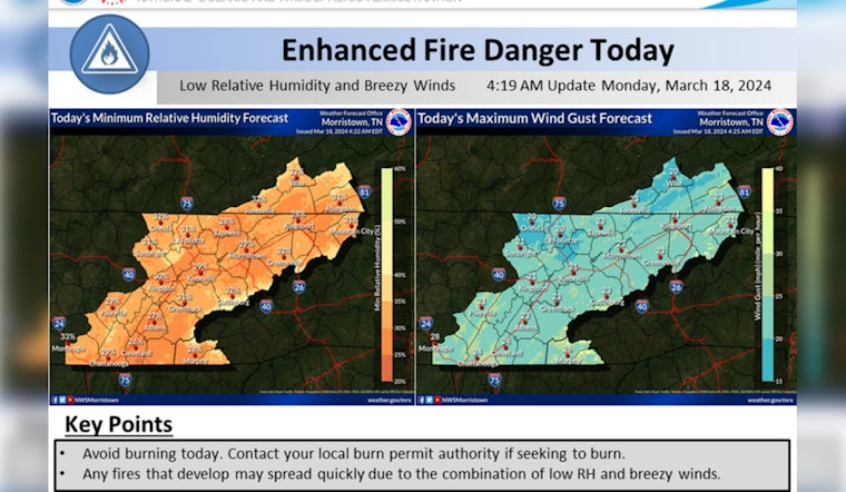
Residents of East Tennessee, Southwest North Carolina, and Southwest Virginia need to be on high alert as gusty winds paired with low humidity levels are posing an elevated fire risk in the region, as per the National Weather Service (NWS) in Morristown. The winds are strong enough, hitting 20 to 30 mph gusts, that even controlled burns can become dangerous. The service urges residents to check with local authorities before igniting any outdoor fires today and Tuesday.
The NWS's special weather statement indicates an "elevated fire risk" expected to last through Tuesday; conditions could allow fires to spread rapidly and become uncontrolled, as today's forecast shows winds gusting between 20 and 30 mph this afternoon and similar conditions are expected tomorrow with slightly lower humidity according to the detailed forecast. Knoxville experienced cloudy skies and a 42°F chill earlier today—with a winds chill factor bringing it down to 38°F—however, it expects a sunny leap to 50°F despite the strong west winds blowing through.
In terms of the week ahead, after facing the elevated risk of fire due to windy conditions, the area is expected to see a rise in temperatures with sunny skies; by Wednesday, the high is forecasted to reach 67°F. But while the warmth might appear inviting, it comes hand-in-hand with the possibility of continued gusty winds—and an ongoing fire threat—that necessitates vigilance.
Knoxville looks forward to clear skies and patchy frost tonight and sunshine peaking through with highs gradually increasing through the week though interrupted by chances of showers rolling in Thursday night into Friday, the city might not get a proper soak until the end of the week, "a 50 percent chance of showers" is on the horizon for Friday, with a high near 60 degrees expected.
The NWS advises residents to refer to local burn permitting authorities regarding whether burning is allowed during these risky conditions. They emphasize the importance of caution when burning as fires could get out of hand quickly under these conditions. For updates and further information, residents can follow the Hazardous Weather Outlook provided by the NWS.


