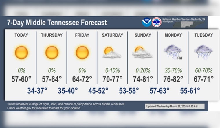
Nashville residents can expect a shift from frosty mornings to balmy afternoons as forecasters predict warmer weather moving in. Today will see sunny skies with a high near 60 degrees and winds from the north northwest at 5 to 10 mph. But don't pack away those winter blankets just yet—tonight could see areas of frost after 5 a.m. with a low around 36 degrees, according to the National Weather Service.
We've got it all for you in the latest 7 day forecast:
— NWS Nashville (@NWSNashville) March 27, 2024
Sunny cool days ✅
Frosty nights ✅
Warm weekend ✅
Stormy start to April ✅ pic.twitter.com/pvxVMcJn1w
Thursdays forecast calls for areas of frost before 8 a.m., making way for another sunny day with temperatures climbing to around 63 degrees. The calm night to follow will potentially bring more frost, leading into a sunny Friday with a significant temperature jump to a high near 71—a welcomed warm-up for anyone weary of winter's chill, as perthe National Weather Service.
The warming trend continues through the weekend, with the National Weather Service predicting a sunny Saturday with the high near 77 degrees and breezy conditions that could see gusts as high as 25 mph. However, evening temperatures drop only slightly to a low around 58 degrees, ample evidence of the gradually increasing warmth.
Colloquially, one might say Nashville is finally tiptoeing into spring with Sunday's partly sunny forecast and highs peaking at 81 degrees, accompanied by winds with gusts up to 20 mph. By Monday, there's a 30 percent chance of showers and thunderstorms, but the heat will persist with a high near 82. Monday night, the chance of precipitation jumps to 60 percent along with the likeliness of thunderstorms, as temperatures hold steady with a low around 58 degrees, as reported by the National Weather Service.


