Chicago is girding for a mix of scattered showers and potential thunderstorms, with the volatile weather being ushered in by a cold front. The National Weather Service Chicago warns of isolated strong to severe thunderstorms this morning, primarily east of I-55. There's a limited tornado risk along with the possibility of damaging winds reaching up to 60 mph. According to the National Weather Service's Hazardous Weather Outlook, those in north central Illinois, northeast Illinois, and northwest Indiana should take extra caution.
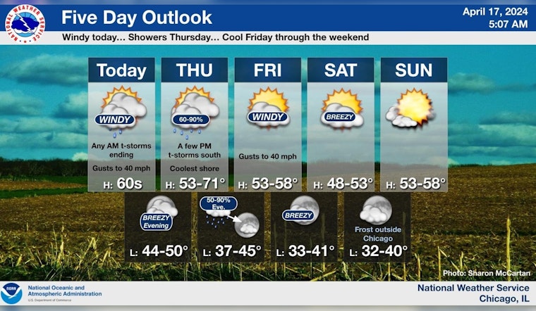
The forecast for today includes cloudy skies with temperatures holding steady around 63 degrees and windy conditions with south breezes shifting west southwest and gusts that could potentially to reach as high as 35 mph. Thunderstorm risks carry on into tonight with most areas seeing a gradual clearing. As for Thursday, showers are likely to persist, mainly after 2pm, bringing less than a tenth of an inch of new precipitation. The detailed forecast anticipates a high near 53 degrees with a west wind turning east northeast in the morning.
Temperatures are set to drop Thursday night with lows around 44 degrees and the likelihood of showers before 2 am. However, relief is in sight as Friday is projected to be sunny with breezy conditions, winds picking up in the afternoon, and gusting as high as 30 mph.
The weekend should bring some respite from the rain with mostly sunny skies and highs near 50 degrees on Saturday. Nevertheless, the clear skies come with an elevated frost and freeze risk from Saturday night into Sunday morning. The National Weather Service Chicago's social media update indicates a small chance for the current storms to intensify, with strong winds and a possible tornado, though it's expected to end swiftly from west to east by late morning. Boaters in the nearshore waters of Lake Michigan are cautioned of hazardous conditions for small craft and a limited waterspout risk for today and tonight.
Scattered storms PSBL this AM with a cold front. Small (~20%) chance exists for some storms to become severe east of black dashed line in graphic. Main threats would be strong winds and a PSBL tornado. This threat ends quickly from west-to-east thru the late morning. #ILwx #INwx pic.twitter.com/d5dU7sILSf
— NWS Chicago (@NWSChicago) April 17, 2024
Next week's outlook hints at a warm-up, with Monday seeing sunny highs of 61 degrees, but showers are likely again by Monday night. The capricious spring weather in the city holds steady as Tuesday also forecasts showers and a partly sunny high near 61. Spotter reports may be necessary today in light of the thunderstorm activities, so local residents should remain alert and prepare for swiftly changing conditions.


