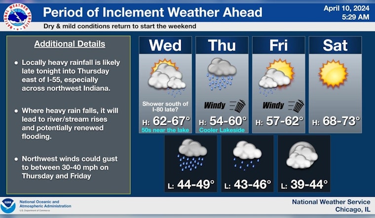
Chicagoans, brace yourselves for a wet and windy midweek. As per the National Weather Service’s latest forecast, today might offer a glimpse of respite with a partly sunny sky and highs touching 59 degrees but don’t get too comfortable. A shift in the wind's direction is expected, transforming the day's lighter breezes into gusts that could reach 15 mph.
Tonight, the tranquility of the skies will be disrupted as rain is likely, mainly after 2 am, with a 70% chance of precipitation, introducing a new siege of watery onslaught with amounts ranging between a quarter and half an inch possible. In an unshielded moment, the northeast wind will pick up speed, charging at 5 to 15 mph. As the week rolls on, rainfall will continue to be the central narrative, with Thursday’s conditions tightening their grip, seeing a high near 49, a north wind blowing fiercely at 15 to 20 mph, and gusts that could go as high as 35 mph, not to mention a 90% chance of precipitation.
The soggy saga continues into Thursday night with showers and a robust west-northwest wind maintaining speeds of 15 to 20 mph and reaching gusts up to 30 mph. In an attempt to escape, Friday may offer a fleeting glance at the sun before 1 pm but only carries a 30 percent probability of drying out completely. The weekend promises a short-lived recovery with mild and dry conditions, boasting a high near 68 on Saturday and an even warmer 75 on Sunday, according to The National Weather Service's detailed forecast.
But fate's dice roll to summon thunderstorms once more by Monday and Tuesday, as the weather pendulum swings back to a chance of showers, encapsulated by brief glimpses of the sun between the clouds. Along the Illinois and Indiana nearshore waters, smallcraft should exercise caution from Thursday through Tuesday due to hazardous conditions forecasted by the National Weather Service's Hazardous Weather Outlook, while limited thunderstorm risks threaten stability on both land and lake.
Cloudiness will be on the increase today leading to rain spreading into the area tonight. Rain will continue Thursday before gradually tapering off Thursday night. Locally heavy rainfall totals are possible east of I-55, especially into NW IN. Dry and mild for the weekend. pic.twitter.com/twzgmW3Q9T
— NWS Chicago (@NWSChicago) April 10, 2024
While the weekend offers a temporary reprieve, the region remains wary of persistent minor flooding near larger rivers and renewed rises potentially beckoning additional flooding and turbulence in low-lying areas. The inclement pattern underscores a broader climate tableau as noted by an advisory from the National Weather Service Chicago on X, calling attention to the heavy rainfall totals possible, especially into NW IN. This latest surge of nature's whims reminds the city that spring's embrace can often come with a cold and wet grip.


