As Houston braces for potential thunderstorms, residents are urged to stay aware of the changing weather conditions that could see some severe activity in the coming days. According to Houston's Weather Forecast, there are scattered showers and thunderstorms in the forecast, mainly after 4 pm today, with a 30% chance of precipitation. The storms rolling into the night may also pack a punch before scattering into isolated showers late into the night.
The National Weather Service's Storm Prediction Center has put forth a detailed discussion forecasting an enhanced risk of severe thunderstorms primarily expected for a sizable region, including parts of Texas. "Potentially widespread strong to severe thunderstorms are expected Saturday into Saturday night. The greatest threat is currently anticipated across parts of the central and southern Plains, where very large hail, damaging winds, and a few strong tornadoes will be possible. A larger area of potential threat will extend from south-central Texas north-northeastward into the Great Lakes." the SPC's Forecast Discussion warns. Residents are advised to closely monitor the situation and to prepare to quickly and safely seek shelter if severe weather warnings are issued.
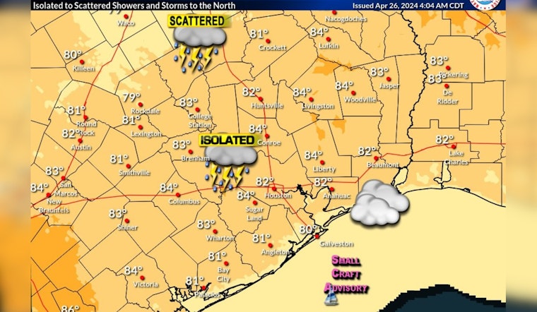
Today's outlook for Houston, as per NWS Houston's post, suggests warm and muggy conditions throughout the day with an increased chance for isolated showers and storms, especially in areas north of the region. Although the immediate threat within Houston itself seems moderate, the conditions support an environment where storm formation is possible with heat catalyzing throughout the afternoon.
Warm, muggy, and breezy conditions are expected today. Isolated showers and storms are possible this afternoon with better chances of storms north of the region.#houwx #txwx pic.twitter.com/WZU79O8Fqd
— NWS Houston (@NWSHouston) April 26, 2024
As we head into the weekend, the likelihood of stormy weather intensifies. Saturday through Sunday promises breezy conditions with scatterings of showers and thunderstorms, where the chance of precipitation peaks at 60%. Houstonians are advised to stay abreast of the latest weather updates, ensuring they're not caught unprepared as storms begin to potentially and aggressively develop in the vicinity of the dryline and near a northward-moving warm front. With these conditions, the severe hazards may not be confined to just hail and winds; strong tornadoes are also a looming threat that could imperil neighborhoods across the affected zones.


