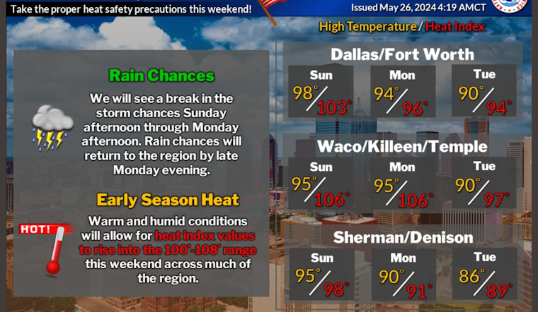
As Dallasites prep for Memorial Day barbecues, the weather threatens to rain on their parade, literally. Forecasters at the National Weather Service Fort Worth TX predict a "20 percent chance of showers and thunderstorms before 10 am" today, followed by a mostly cloudy morning that should clear up to a sweltering high near 98 degrees, as reported by the National Weather Service. Not just hot, today's conditions take it up a notch with heat index values cranking as high as 105, so hydrate or die-drate if you're heading outdoors.
Tonight's skies will be clearer with cooler temps around 72 to give everyone a breather; however, the heat isn't taking a holiday, as Memorial Day is expected to boast sunny skies and a high near 93, and Tuesday isn't far behind with a chance for thunderstorms in the afternoon bringing a high near 91 according to the weather forecast. While the sun's making a persistent cameo throughout the week, rain threats loom large with the forecast indicating a 30 to 50 percent chance of showers and possibly the odd thunderstorm nightly from Tuesday right into the weekend.
According to the Hazardous Weather Outlook, some storms could pack a punch with wind gusts between 40 to 60 mph lasting until about 10 AM today, and there's a chance for small hail and heavy rainfall, especially in Central Texas. Folks in eastern Central Texas are getting the worst of the heat with maxed-out heat index values hitting between 105-109 today and tomorrow.
As for the rest of the week's post-holiday festivities, don't pack away those umbrellas just yet, storm chances might make a comeback as soon as Monday evening, and though predictions are shady about severity, forecasters can't rule out some tumultuous weather ahead, so stay tuned; spotter activation is not expected at this time, but stay informed, Dallas, mother nature might just have her post-holiday fireworks in store.


