The city of Dallas faces a potentially tempestuous week ahead, with weather forecasts predicting a rollercoaster of heat and hazardous conditions. According to the National Weather Service's latest communication, an added layer of complexity blankets Dallas with a mix of sweltering heat, patchy fog, and the threat of severe thunderstorms. Today’s outlook includes fog fading by 10 am, giving way to a mostly sunny sky with a high nearing 91 degrees and heat index values peaking at 101. Southerly winds are pushing gusts up to 25 mph, stirring more than just the air—it's stirring a sense of caution among residents.
Tonight holds an unpredictable edge as "a slight chance of showers and thunderstorms between 9 pm and midnight" is on the forecast, emblematic of the turbulent weather narrative gripping the city. Despite a mere 20 percent chance of precipitation, the storms brewing in potential could be severe, ushering in a period of vigilance and preparedness. The winds will persist, hustling at around 15 mph from the south-southeast, with gusts up to 30 mph, according to the National Weather Service.
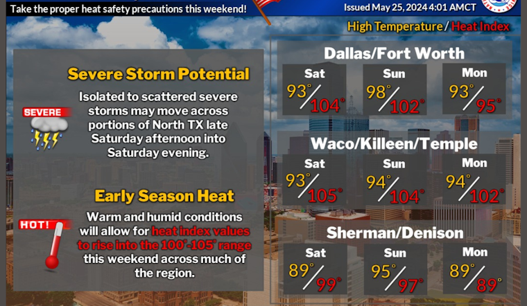
The forthcoming Sunday seems set to sizzle with a high near 98 degrees and heat index values soaring to an oppressive 104. The barrage of mercury-rising days continues into Memorial Day with clear, sunny skies, and a high near 94. The balmy conditions seem to beck with a deceptive invitation to outdoor festivities, yet the undercurrent of storm potential lingers, looming discretely in the weather narrative.
However, respite may be short-lived as rainy possibilities threaten to return midweek. Forecasts anticipate a 20 to 40 percent probability of showers and thunderstorms starting Monday night through to Friday. With it, temperatures moderately ease, hovering in the mid-80s to around 90 degrees, promising a reprise from the earlier stifling heat. The National Weather Service's Hazardous Weather Outlook alerts that "an isolated severe thunderstorm or two may impact portions of North Texas," with particular attention to areas north of I-20 and west of Highway 75.
While the city bathes in the warmth of a Southern spring, this cocktail of meteorological conditions serves as a somber reminder that Mother Nature plays by her own rules and demands respect. Storm spotters may find themselves on call this evening, with possible activation in selected regions of western North Texas post-5 PM, as stated by the National Weather Service. The week ahead in Dallas is a complex mosaic of warm, sunny days tempered by the sporadic punctuation of thunderstorm threats—a tableau of Southern weather in Spring.


