Dallas residents can expect a mixed bag of weather in the coming days, with a chance of showers and thunderstorms starting today. The unpredictable conditions begin with a "20 percent chance of showers and thunderstorms before 4 pm" and "patchy fog before 10 am,", according to the National Weather Service. These scattered showers will give way to mostly clear skies by nightfall, with a low of around 64 degrees.
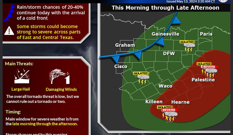
Coming days are shaping up to include more sun, with Tuesday and part of Wednesday expected to be sunny, with highs in the mid-80s to high 80s. But the respite is short-lived. The Hazardous Weather Outlook, also released by the National Weather Service, warns of "thunderstorms expected across the region today" and states that "a few severe storms will be possible." Hail and damaging winds are cited as the primary threats for today and tonight.
The interlude of pleasant weather won't linger, as storm chances ramp up again Wednesday night, carrying into the weekend. Severe weather could return Wednesday night and Thursday, but details remain hazy. In addition to storms, "Heavy rainfall may renew flooding across the region," increasing concerns about water-logged grounds and swollen waterways, per the Hazardous Weather Outlook.
This week's weather rollercoaster is not just about precipitation. Wednesday night's storm chances come with a "30 percent chance of showers and thunderstorms after 1 am," moving into Thursday, which shows a heftier "60 percent chance of precipitation." Swaths of Texas, including Dallas, brace for the possibility of more severe weather with the National Weather Service urging locals to stay informed as the situation develops. The overall picture paints a Texas primed for both sunshine and storms, an all too familiar, if not unsettling, dance with the elements.


