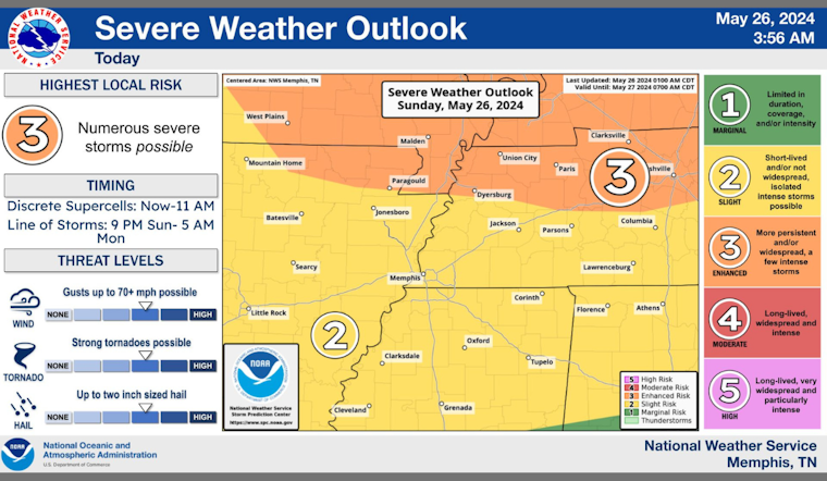
A Flood Watch alert has been maintained for regions across East Arkansas, Southeast Missouri, and West Tennessee, with forecasts warning that the conditions are primed for potential flooding through Monday morning, according to the National Weather Service in Memphis. The alert comes after a whopping over 4 inches of rain pummeled the region in the last week alone, fostering flood conditions that have already swept across streams and roadways, posing new threats to these areas as the downpour is expected to continue.
The NWS has advised residents to stay vigilantly on the lookout for possible Flood Warnings and to be prepared to react should these areas experience flooding. Flooding risks are particularly pronounced in urban and poor drainage locales, where excessive rainfall is likely to quickly accumulate. "Excessive runoff may result in flooding of rivers, creeks, streams, and other low-lying and flood-prone locations," according to the National Weather Service. They went on to stress that "Creeks and streams may rise out of their banks," a troubling forecast for residents already wearied by the recent bouts of extreme weather.
In a detailed forecast, meteorologists expect a slight chance of showers and thunderstorms today, intensifying tonight with more showers and thunderstorms likely before giving way to a sunny Memorial Day. Following the holiday, clear skies are anticipated on Monday night, with sunny conditions returning on Tuesday. However, the respite could be short-lived as there's a chance for more showers and thunderstorms later in the week.
With the situation developing, authorities encourage people to rigorously monitor personal safety measures and to be ready to act promptly to safeguard against the impacts of potential flooding. Residents in flood-prone areas are advised to shore up their readiness, as the water levels are expected to continually rise and could potentially surge to dangerous levels.


