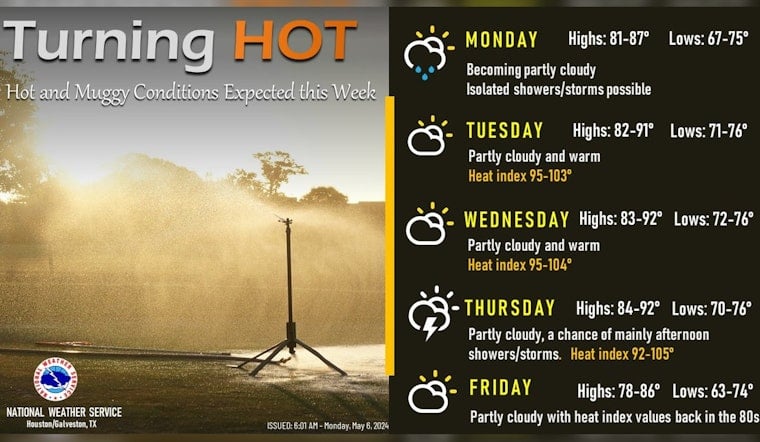
Houstonians are bracing for a week of sweltering heat with temperatures forecasted to climb into the upper 80s and 90s, even reaching triple-digit heat indices, prompting warnings from local weather authorities to take heat safety measures seriously.
Monday's weather kicked off with a gloomy forecast, carrying a 20 percent chance of morning showers and thunderstorms, accompanied by the possibility of patchy fog before the skies cleared up some, leaving Houstonians facing a high of 85 degrees and gusty winds up to 20 mph, according to the National Weather Service; whereas come nighttime, the clouds will linger with a low around 76 degrees, keeping the humid backdrop intact.
The real story this week, as confirmed by NWS Houston on X, is the significant rise in temperature Tuesday leading into the weekend, with a forecasted high near 90 degrees on Tuesday and the mercury hovering close to 91 degrees midweek; Houston residents will face heat index values as high as 101, making it essential for locals to stay hydrated and take periodic breaks from the heat.
The main weather story this week will be the heat. Temperatures will warm into the upper 80s and 90s with heat indices in the triple digits.
— NWS Houston (@NWSHouston) May 6, 2024
Make sure to take proper heat safety precautions. pic.twitter.com/XXtaXxhA7m
The weather narrative takes a turbulent turn with the Storm Prediction Center's announcement of a "There Is a slight risk of severe thunderstorms across parts of the mid-south into Ohio Valley" rolling through regions beyond Houston, with violent winds, hail, and even tornadoes possible as a large upper cyclone trudges slowly across the northern Plains scary enough, the dominos fall in a chain as these conditions play out on a broader scale with scattered yet severe thunderstorms forecasted northeastward into the Ohio Valley, driving concerns for a spectacle of nature's volatility amid the already oppressive heat.
The week's forecast hints at a reprieve by Thursday, offering a mix of sun and clouds with "A 20 percent chance of showers and thunderstorms after 1pm. Partly sunny, with a high near 90," as per the National Weather Service, winding down to more agreeable conditions, a mostly sunny Friday and Saturday with mercifully cooler highs dipping back into the low 80s, giving city dwellers a break before the potential for more rain and storms Sunday.


